
 Search
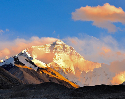


The tour from Lhasa to Kashgar starts from Lhasa, the capital of Tibet, at an altitude of 3,490 meters above sea level. The trip follows the G318 Friendship Highway to the far west of Tibet, before turning north on the G219 national road, taking you to the famous Mt. Kailash, the most sacred mountain in the world, before continuing on to Kashgar in the Xinjiang Uyghur Autonomous Region in the far northwest of China.
This long-forgotten land in the farthest corner of China is hardly ever visited, and is a remote desert oasis filled with fascinating scenery and tremendous sights. A land of ancient kingdoms, herds of wild donkeys roam the plains while great eagles soar high in the sky. One of the hubs of the ancient Silk Road from China, Kashgar is a land of pleasant and friendly people, where groups of nomads roam the northern plains tending their flocks of goats and sheep, and herds of yaks.
On the way, you will get to visit that holiest of mountains, Mt. Kailash, the sacred mountain of four religions, in whose shadow four of the world’s mightiest rivers begin. A favored pilgrimage destination for Hindus, Buddhists, Jains, and Bonpo, Mt. Kailash is the heart of the region, where gods reside and mystical heroes battled with magic on the mountainside.
Why We Choose Xinjiang Tibet Highway?
China’s National Highway 219, also known as the Xinjiang Tibet Highway, runs along the western border of China with Nepal and India, and is one of the highest roads in the world. The Xinjiang Tibet Highway is an important road that connects Xinjiang Uyghur Autonomous Region with Tibet, and ultimately the rest of China. Though it is a road of poor condition, the scenery along the route is more than enough to make up for the rough and rugged trip. Crossing five mountain passes over 5,000 meters, and more than 40 glaciers along the route, travel along this road to Xinjiang is like wandering through a dream world.

Take a Lhasa Kashgar overland tour via Xinjiang Tibet Highway
The road is 2,086 kilometers long from its start in Lhatse, where it leaves the Sino-Nepal Friendship Highway, to its end point at Yecheng in Xinjiang. A long and arduous journey, it attracts travelers to the route because of the long drive through arid deserts and past stunning glaciers, as it travels north. Even with wild sandstorms and arid desert, as well as the increased chance of acute altitude sickness, intrepid explorers of this bare and desolate region are not in short supply. In fact, the harsh and hazardous conditions actually attract people for the adventure.
The road is one of high altitude ice passes and stunning desert scenery that will take your breath away, and is in better conditions now, after being paved with asphalt in many parts, than it was when it was first built as no more than a gravel road across a desolate no-man’s land. People who are willing to travel along the G219 are those with a desire for adventure, and the route is said to have the highest section of road in the world, at an altitude of 5,248 meters near Jieshan Daban in Ritu County of Tibet.
Another major attraction for this route is the fact that, despite traveling through some of the most desolate country in the world, it passes by a large number of big attractions. As the road stretches out across Ngari Prefecture of Tibet, it passes by the famous Mt. Kailash, the holy mountain of four religions, and Lake Manasarovar, one of the three Great Lakes of Tibet, and another site that is sacred to Buddhists and Hindus. And not far after leaving the area of Mt. Kailash, travelers have the opportunity to visit the ancient ruins of the Tibetan Guge Kingdom, which dates back to the 10th century, before the Tibetan Empire was born.
But the route along the Xinjiang Tibet Highway is not just desolation and desert. Even in these high-altitude areas, where people rarely go, there are signs of life all around. As you drive along the highway, you may see some of the wild donkeys and Tibetan antelope that roam the region north of Mt. Kailash.
Xinjiang Tibet Highway Travel Route and Altitude Changes
While there are actually two routes one can take to get to Shiquanhe in Ngari Prefecture, the route using the G219 is by far the more popular one. Starting in Lhasa, at an altitude of 3,650 meters, the journey starts by traveling along the G318 National Highway, also known as the Sino-Nepal Friendship Highway. The route along the G318 passes through Gyantse (3,950m) and Shigatse (3,900m), before reaching the intersection of the G318 and the G219 at the town of Lhatse in Shigatse Prefecture, which lies at an elevation of 4,050 meters.
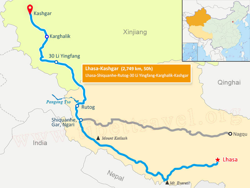
Xinjiang Tibet Highway Map
From Lhatse, the road splits off to head northeast towards the Nepal border, first passing through Ngamring County of Shigatse, the gateway to Mt. Kailash and the far west of Tibet. A barren area that lies between the Brahmaputra and the Raga Tsangpo Rivers, Ngamring lies at an average altitude of 4,380 meters. From Ngamring, the route heads west to Saga County, and the town of Saga, the county seat, which lies at an elevation of 4,640 meters.
After Saga, the route heads through Zhongba County, the largest county in Shigatse Prefecture. The region, which lies at around 4,640 meters, is prone to earthquakes, the worst being in 2008, and is dotted with over a dozen lakes of many different sizes. Burang County, the first of the counties in Ngari Prefecture, lies at an elevation of 4,755 meters and is the home of the sacred Mt. Kailash and Lake Manasarovar. This area is the river nexus of the Himalayas, and contains the source of the four great rivers of Asia, the Indus, the Sutlej, the Ganges, and the Brahmaputra Rivers.
Gar County of Ngari Prefecture sees the continuation of the G219, as it passes through the county seat of Shiquanhe at 4,255 meters. Shiquanhe was once known as Gar Town, and the name Shiquanhe was taken from the river that runs through the town, the Sengge Zangbo. As the route moves on, it passes through Rutog County, the last county in Ngari and Tibet, before reaching Xinjiang. Rutog County lies at an average elevation of 4,300 meters, and the road passes over its highest point at the Mariom La pass, at 4,725 meters.
As the road passes through Rutog County, it skirts the southeast shores of Bangong Co (5,400m), a long, slim lake that stretches from Rutog County, through the disputed area of Aksai Chin, which is a part of Hotan County of Xinjiang Autonomous Region, and on into Jammu and Kashmir. The first point of Xinjiang that the road meets is just to the west of Quanshui Lake (5,137 meters), along an immense valley that ends at the Hongshan Hu Lake in Hotan County. The route crosses the disputed area at its western edge, and crosses the remaining area of Hotan County to Kashgar Prefecture of Xinjiang. Kashgar City lies around 900 kilometers from the boundary with Tibet, and lies at an altitude of just 1,270 meters, and is off the edge of the huge Tibetan plateau.
Highlights of Lhasa Kailash Kashgar Overland Trip
With an elevation at its peak of 6,714 meters, the most popular and famous attraction along the Xinjiang Tibet Highway is the sacred Mount Kailash. Lying in the Gangdise Mountain Range, Kailash is the pilgrimage site for thousands of Buddhists and Hindus who visit the holy mountain every year to circumambulate the mountain in holy reverence and prayer. Lying a little way to the south is the holy Lake Manasarovar, a sacred site for four religions, and one of the Great Three Holy Lakes of Tibet.

Mount Kailash
To the north of Mt. Kailash lie the ruins of the ancient Guge Kingdom, in Zanda County of Ngari. Now, all that remains of the great kingdom that once ruled the area in the northwest of Tibet are ruins, and the kingdom was incorporated into Tibet in the late 17th century.
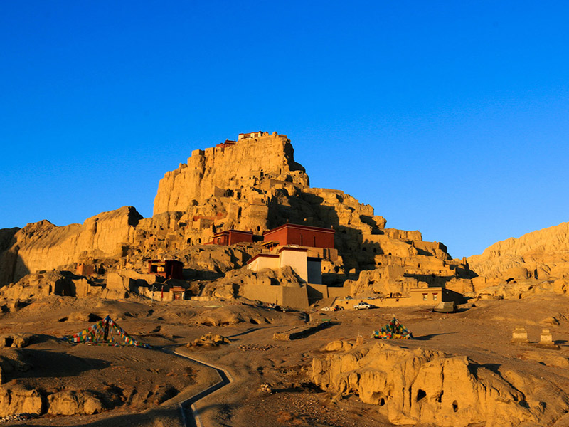
Guge Kingdom
One of the best views when driving along the Xinjiang Tibet Highway are the Karakoram Mountains, a range in northwest China that averages over 6,000 meters and has four peaks of more than 8,000 meters. The range includes a huge number of Snow Mountains, and is known to have the most developed giant glaciers in the world.

Karakoram Mountains
Majority of the Xinjiang Tibet Highway from Saga to Kashkar runs through some of the most desolate and deserted landscapes in the world. So far from major centers of civilization, the region in northwest Tibet and southwest Xinjiang is the home to a huge number of species of wild animals that are indigenous to the region. As well as the ever-present yaks and Tibetan antelopes, of which there are herds of thousands in the plains, you may also have the chance to see Mongolian gazelles, blue sheep, and the famous bighorn sheep of northern Asia. And if you are really lucky, you may get to spot one or two of the natural predators of the region, such as the snow leopard, Asian black bears, and wolves, which still run wild on the plains of northern Tibet and across southern many parts of Xinjiang.
>> Check the details of 16 Days Tibet to Xinjiang Land Trip
>> Check the details of 24 Days Tibet and Southern Xinjiang Adventure
Best Time to Travel Overland to Kashgar from Lhasa
As this part of China is well known for its harsh climate, much more so than the rest of Tibet, with strong sandstorms and extremes of temperature throughout the year, the best times to travel along the highway to Kashgar is from May to early July and from September to October.
The rainy season in the region runs from July to September, and the condition of the road often become s impassible in places, making travel almost impossible. From around the end of October, the winter weather takes a hold, and temperatures drop dramatically with snowfall as early as the start of November, which lasts until late April.
Travel Visas and Permits Needed
As with all tourists in Tibet, certain permits are required, as is the need to be on a pre-arranged tour with a registered guide, private vehicle, and a driver. The first thing to acquire is your Chinese Entry Visa, which you can obtain from the Embassy of the People’s Republic of China in your home country, or country of residence.

Tibet Travel Permit
Once you have the Chinese Entry Visa, your tour operator will apply for the other permits you need, which include the Tibet Travel Permit, to get in and travel around Tibet, and the Alien’s Travel Permit (obtained in Lhasa), to travel to the unopened areas of Tibet, such as Ngari. The Military and Border permits, which you will need to get into the area of Mount Kailash and the border regions with Nepal and India, will also be acquired by your guide whilst in Lhasa.
Xinjiang Autonomous Region does not have the same restrictions as Tibet, and is classed as just another province of China. As such, you will not need any special permits to enter and travel around the region, as long as your Chinese Entry Visa is still valid for the duration of your stay.
However, there are certain places in Xinjiang where you will need a permit. There are many roads in Xinjiang, such as the Karakoram Highway, where you will need a permit to drive along the road, and the G217 national Road from Kuqa in Aksu Prefecture to Hotan Town in Hotan Prefecture also requires a permit to drive along. These permits can be obtained by tour operators such as Tibet Vista, to allow driving along the roads where permits are required.
Dining and Accommodation along Xinjiang Tibet Highway
While there are plenty of places to stay on the G318 section of the route, and even a good number of spots to eat or stay between Lhatse and Saga, the far northwest of Tibet and into Xinjiang has very little in the way of accommodations and eateries for travelers. It is best advised to take your food with you, and prepare tents with good arctic sleeping bags for the cold nights, as finding suitable accommodation every night along the route may not be possible.
Tibet Xinjiang Overland Tour Packing List
Ngari Prefecture of Tibet is at a higher altitude than the rest of the region, and the temperatures rarely get into double figures, some days not even lifting above freezing, even in the spring and fall. Warm clothing is a must on this journey, and strong hiking boots with thick, warm socks are recommended, as the ground is very often rough and rocky, with few smooth patches of terrain. An arid desert region, Ngari and southern Xinjiang are both at high altitudes, and the climate is windy and harsh, with high, freezing peaks all around in the Karakoram Mountains.
All medications you may need as prescribed by your doctor should be taken with you, and ensure that you have enough for the entire trip with some extra for emergencies, and it is a good idea to discuss altitude sickness medication with your doctor before you leave, as the region has some extremely high altitudes. Some travelers even use supplemental oxygen when driving through the highest parts of Ngari and into Xinjiang. And a good first aid kit in case of accidents or scrapes should be included.
At such a high altitude, and with such strong winds, hats and gloves should be worn, and sunglasses to keep out the bright light of the sun, as well as using lip balm and moisturizers to help keep your lips and face from being damaged by the extreme winds.


"Ultimate Guide to Lhasa Kailash Kashgar Overland Tour via Xinjiang Tibet Highway"