
Map of Nepal and India
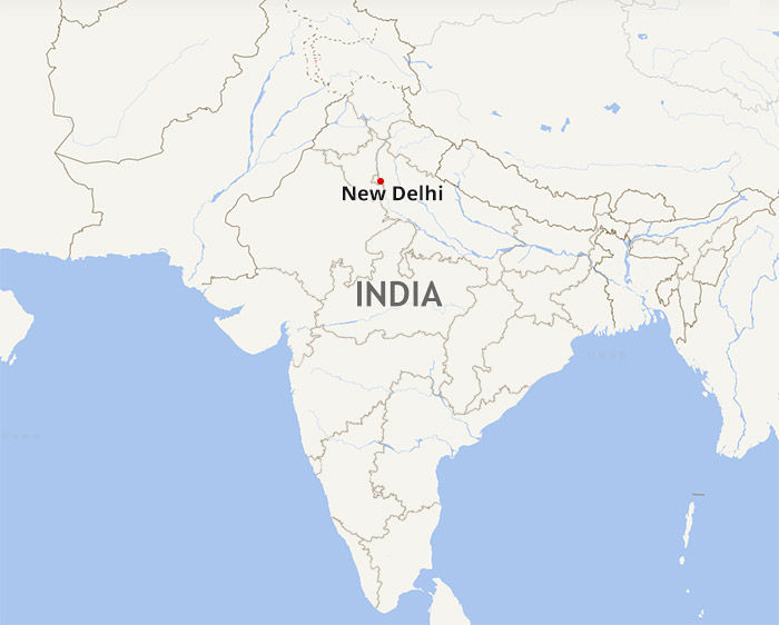
India, short for the Republic of India, is the largest country in the South Asian Subcontinent. Facing to Sri Lanka and Maldives, India shares border with Bangladesh, Burma, the People's Republic of China, Bhutan, Nepal and Pakistan.
Known as one of the four great ancient civilizations, India is the cradle for diverse religions, like Hinduism,Buddhism, Jainism, Sikhism, etc. It's also endowed with rich cultural heritage and diverse natural landscapes. Taj Mahal, the Ganges, Agra Fort and Harmandir Sahib are the top destinations for tourists to visit India. However, India has more to offer. Thanks to its ease access to neighboring countries and regions, millions of tourists have traveled from India to Nepal and Tibet.
Map of Indian States and Union Territories
As the world's 7th largest country, India covers a total area of about 2.98 million square kilometers, spanning 3,214 kilometers from north to south and 2,993 kilometers from west to east. The capital city is New Delhi and other metropolises include Mumbai, Bangalore, Chennai, Hyderabad, Ahmedabadand Kolkata, etc. It consists of 29 states and 7 union territories:
 (Simple click to enlarge the map)
Latest India Map with State Names
Name list of 7 union territories in India: A. Andaman and Nicobar Islands, B. Chandigarh, C. Dadra and Nagar Haveli, D. Daman and Diu, E. Lakshadweep, F. National Capital Territory of Delhi, G. Puducherry
Note: Arunachal Pradesh as well as Jammu and Kashmir are the disputed border regions among India, China and Pakistan.
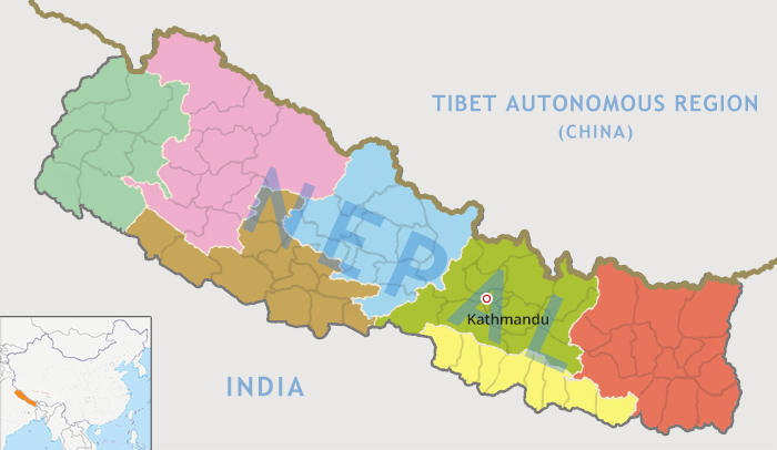
Nepal District Map
 (Simple click to enlarge the map)
Nepal Map with All Districts
As the world's 94th largest country, Nepal has a total area of 147,181square kilometers. It runs in the northwest-southeast direction, extending 850 kilometers from north to south and 2,00 kilometers from west to east. Nepal's capital city is Kathmandu and other big cities include Pokhara, Biratnagar, Lalitpur, Bharatpur, Birganj, Butwal, Dharan, Bhim Datta and Dhangadhi, etc. In 2015, Nepal is divided into 7 provinces and 75 districts. Those administrative divisions are simply called as Province No.1, Province No.2, Province No.3, Province No.4, Province No.5, Province No.6 and Province No.7.
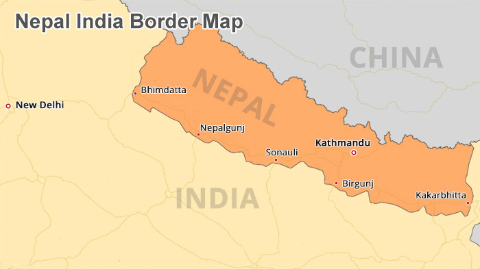
Nepal India Border Map
India is the largest country in South Asia, surrounded by the Bay of Bengal on the southeast, the Indian Ocean on the south, and the Arabian Sea on the southwest. In its northern area, India is bounded with Pakistan on the northwest, China, Nepal and Bhutan on the northeast, Burma and Bangladesh on the east. Major India Nepal border crossings are as follows:
 (Simple click to enlarge the map)
India Nepal Border on Map
Sonauli - the biggest and busiest India-Nepal border crossing
Location: Maharajganj District, Uttar Pradesh State, India
Coordinates: 27°28′N 83°28′E
Time Zone: UTC+5:30
Distance: about 90 km from Sonauli to Gorakhpur, 7 km from Sonauli to Nautanwa Railway Station
Attractions around Sonauli: Lumbini
Bhimdatta (formerly known as Mahendranagar) - close to Banbansa
Location: Kanchanpur District, Province No.7, Nepal
Coordinates: 28°55′N 80°20′E
Time Zone: UTC+5:45
Distance: 5km from Bhimdatta to the border of India and the Mahakali River, 700 km from Bhimdatta to Kathmandu
Attractions in Bhimdatta: Shuklaphanta Wildlife Reserve
Kakarbhitta - close to Panitanki, Siliguri, Darjeeling and Kolkata
Location: Jhapa District, Province No.1, Nepal
Coordinates: 26°38′N 88°09′E
Time Zone: UTC+5:45
Distance: 1700 meters between Kakarbhitta and Panitanki
Attractions in Kakarbhitta: Satighata tea plantation
Birgunj (Birganj) - close to Raxaul Bazzar, the entry point from Patna and Kolkata to Nepal
Location: Parsa District, Province No.2, Nepal
Coordinates: 27°0′N 84°52′E
Time Zone: UTC+5:45
Distance: 183 km from Birgunj to Kathmandu
Attractions in Birgunj: Gahawa Mai Temple
Nepalgunj (Nepalganj)- close to Jamunaha and Lucknow
Location: Banke District, Province No.5, Nepal
Coordinates: 28°03′N 81°37′E
Time Zone: UTC+5:45
Distance: 85 km from Nepalgunj to Ghorahi, 10 km from Nepalgunj to Kohalpur, 35 km from Nepalgunj to Gularia
Attractions in Nepalgunj: Bageswory Temple, Banke National Park, Bardia National Park, Karnali River
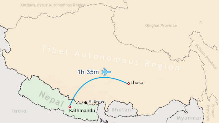
How to Travel from Nepal to Tibet?
 (Simple click to enlarge the map)
Kathmandu to Lhasa Flight Route Map
So far, Zhangu Port and Gyirong Port still remain closed to tourists. You can only travel between Tibet and Nepal by air. The linear distance between Lhasa and Kathmandu is around 609km. It takes you about one hour to fly from Kathmandu to Lhasa. Currently, Air China and Sichuan Airline have flights between Tibet and Nepal.
Note: If you enter Tibet from Nepal, a Group Tourist visa is required. See more at Tibet Travel Permit
How to Travel from India to Tibet?
Since there is no direct train and flight to Tibet from India, most tourists would choose to get to Nepal or China first and then transfer to Tibet.
1. Travel from India to Nepal and then fly from Kathmandu to Lhasa
a. Fly from India to Kathmandu
The fastest and easiest way to Nepal from India is by air. Tourists can take direct flights from Delhi, Mumbai or Kolkata to Kathmandu and tour around Nepal before flying to Tibet.
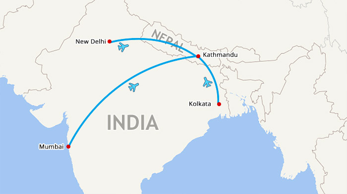 (Simple click to enlarge the map)
India to Nepal Flight Route Map
b. Travel overland from India to Nepal
Tourists can also travel overland from India to Kathmandu and then fly to Lhasa. Major India to Kathmandu overland routes are as follows:
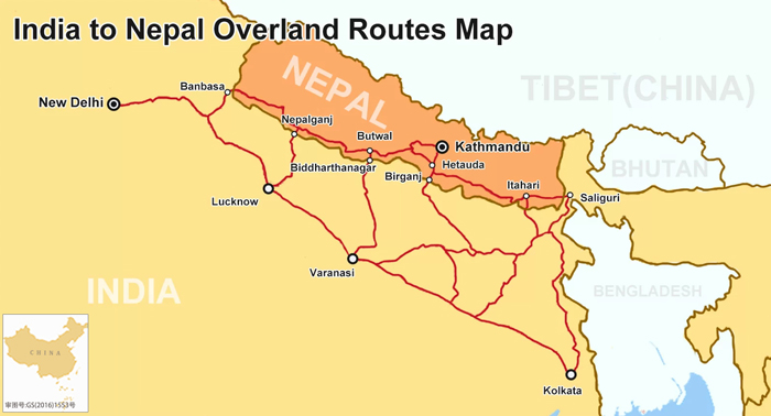 (Simple click to enlarge the map)
India to Nepal Overland Route Map
Delhi/Varanasi - (by bus) - Sunauli - Bhairawa - (by bus) - Kathmandu (the most popular);
Delhi/Varanasi - (by train) - Gorakhpur - (by bus) - Sunauli - Bhairawa- (by bus) - Kathmandu;
Delhi/Varanasi - (by direct bus) - Kathmandu
Delhi - (by bus) - Banbansa - Bhimdatta - (by bus) - Kathmandu;
Darjeeling - (by bus) - Siliguri - (by bus) - Panitanki - Kakarbhitta - (by bus) - Kathmandu;
Kolkata - (by train) - Siliguri - (by bus) - Panitanki - Kakarbhitta - (by bus) - Kathmandu;
Kolkata - (by train) - Raxaul Bazzar - Birganj - (by bus) - Kathmandu;
Lucknow - (by bus) - Jamunaha - Nepalganj - (by bus) - Kathmandu.
Note: If you enter Tibet from India via Nepal, a Group Tourist visa is still needed.
2. Travel from India to China and then go to Tibet by train or flight
Another option is to fly to China first and then take Tibet train or flight to Lhasa. Below are direct flights from India to China:
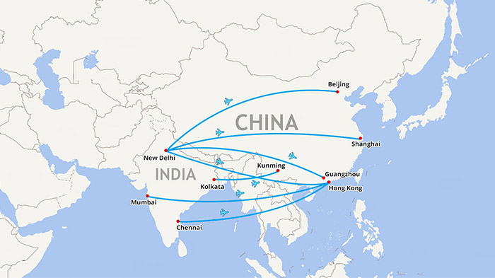 (Simple click to enlarge the map)
India to China Flight Route Map
Flight from Delhi to Beijing, Shanghai, Guangzhou and Hongkong
Flight from Mumbai to Hongkong
Flight from Kolkata to Kunming
Flight from Chennai to Hongkong
Besides, there are some connecting flights between China and India. Please feel free to contact our Tibet travel expert for more information.
India Nepal Tourist Map
Known as one of the four great ancient civilizations, India is the cradle for various religions and vibrant cultures. Attractions in India can be roughly classified into three groups, namely, ancient mausoleums, grand caves and holy temples. Here are top ten attractions in India.
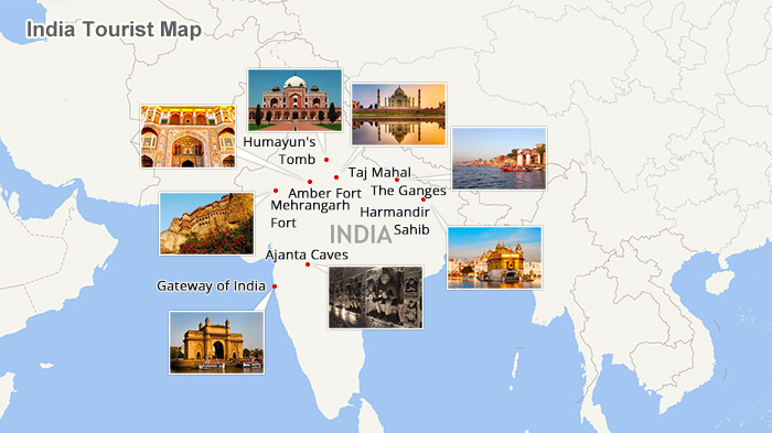 (Simple click to enlarge the map)
India Attraction Map
Taj Mahal-The Symbol of India
As one of the Seven Wonders of the World, Taj Mahal has its romantic love legend. Taj Mahal is actually a mausoleum, which was designed by Shah Jahan, the Mughal emperor, to treasure the body of his favorite wife, Mumtaz Mahal. It took 22 years and tens of thousand of workers to complete. Shah Jahan once intended to build an identical black tomb for himself at the other side of the river and connect it with his wife's mausoleum by a black-and-white bridge. But his son seized the throne and put him in prison. Tragically, Shah Jahan had spent the rest of his life in the Agra Fort only to see Taj Mahal in the far distance. The amazing thing is Taj Mahal will show you different characteristics at different times of the day.
Best Time to Visit Taj Mahal: at dawn or dusk
Address: Taj Mahal, Agra, Uttar Pradesh
Ticket price: Rs 750
Opening hours: 6: 00-19: 30
Agra Fort
Having a history of more than 400 years, Agra Fort is the former imperial residence of the Mughal Dynasty. In 1983, Agra Fort was designated as a UNESCO World Heritage Site. Lying 2.5 km northwest of Taj Mahal, the spectacular Agra Fort was built in red sandstones. It houses more than 500 buildings, including Diwan-i-Am (Hall of Public Audience), Diwan-i-Khas (Hall of Private Audience), Jehangir's Palace, the octagonal Musamman Burj tower, etc. You must be amazed at exquisite art sculptures on the ancient walls.
Address: Rakabganj, Agra, Uttar Pradesh
Ticket price: Rs 300
Opening hours: Sunrise - Sunset
Amber Fort
Established in the year of 1592, Amber Fort was the residence of the Rajput Maharajas and their families. It's also known as Amber Palace with artistic Hindu style element. Located on the high hill, Amber Fort offers you a great chance to catch a panoramic view of Jaipur. One thing you shouldn't miss out is the Sheesh Mahal (the mirror palace). Embedded with glass, it seems like sparkling under the brilliant sunshine.
Address: Amber Fort, Jaipur, Rajasthan
Ticket price: Rs 100
Opening hours: 9:00-16:30
Mehrangarh Fort
Situated in the ancient town of Jodhpur, Mehrangarh Fort was constructed by Rao Jodha in 1459. It is one of the most spectacular castles in India. Standing on the giant cliffs, the well-preserved fort was built in yellow sandstones with solid walls surrounded by. The delicate carvings and marvelous courtyards reveal the city's glorious past. It's a fascinating place for you to dig deeper into Indian history.
Address: Mehrangarh Fort, Jodhpur, Rajasthan
Ticket price: Rs 250
Opening hours: 9:00-17:00
Hawa Mahal (Palace of Winds or Palace of the Breeze)
Constructed in the middle of the 18th century, Hawa Mahal has attracted tourists' eyeball for pink walls and countless windows. As a great masterpiece in Indian architecture, Palace of the Breeze was originally built for the women of the royal family to view the bustling streets and hilarious festivals. Walking around, you can feel winds blowing in from every corner. The best time to visit Hawa Mahal is the early morning when the palace is lit with the golden light of sunrise.
Address: Johari Bazar Road, Jaipur, Rajasthan
Ticket price: Rs 50
Opening hours: 9:00-17:00
The Ganges
The Ganges, also known as Ganga River, is India's mother river. It is the most sacred place in pilgrims' heart. Millions of Hindus come from every corner of India to Varanasi to bath in this holy river for purification. They believe that the Ganges water can wash away iniquity and pain, and help the soul ascend to the heaven. When the Hindus died, the family member would bring their ashes to the Ganges. There are more than 80 Ghats along Ganga River. Each one has its own name and function. Dasashwamedh Ghat and Manikarnika Ghat are the most popular ones among tourists.
Address: Ganga River, Varanasi
Ticket price: free
Opening hours: 24 hours
Humayun's Tomb
It was the first garden-tomb in the Indian Subcontinent and constructed by the Mughal Emperor Humayun's son Akbar. The elegant characteristics and special structure make Humayun's Tomb stand out from the world's architectures.
Address: Mathura Road, New Delhi
Ticket price: Rs 250
Opening hours: Sunrise - Sunset
Ajanta Caves
Located in the tough cliffs, Ajanta Caves has truly recorded India's art, history, Buddhism as well as the royal life. It treasures lots of art works, like elaborate sculptures, delicate paintings, etc. Since 1983, the Ajanta Caves have been a UNESCO World Heritage Site.
Address: Ajanta Caves, Mumbai, Maharashtra
Ticket price: Rs 250
Gateway of India
Facing to Arabian Sea, Gateway of India is located in the Apollo Bunder, Mumbai. It was built in 1911 for commemorating the arrival of King George V and Queen Mary. This 26-meter-hight arch, a fusion of Indian culture and Persian characteristics, has become the symbol of Mumbai, welcoming guests from all over the world.
Address: Apollo Bunder, Mumbai, Maharashtra
Ticket price: free
Harmandir Sahib (Golden Temple of Amritsar)
Harmandir Sahib, also called as the Golden Temple Indiaa, is the holiest temple of Sikhism. Located at the center of Amritsar, Golden Temple was constructed by the fifth Sikh Guru, Guru Arjan in 1598. It is a blend of Hindu and Isalamic styles. You can appreciate the circular domes on the top and splendid towers nearby. It's also known as the world's largest soup kitchen. Regardless of religion, culture or background, all the visitors can enjoy the food for free.
Address: Golden Temple Road, Amritsar, Punjab
Ticket price: free
Squeezing between China and India, Nepal is famous for eight of the world’s ten highest mountains. Meanwhile, you can pay a visit to the splendid palace buildings and countless cultural heritages, such as Durbar Square, Temple of Kumari, Hanuman Dhoka, Swayambhunath, Pashupatinath, Golden Temple and so on. See more at Nepal Tourist Map

Kham Sang is responsible and honest with more than six years of guide experience in Tibet.She has strong interpersonal skills and can communicate effectively with tourists.

.jpg)



0 Comment ON "Map of Nepal and India"