

.jpg "Tibetan Local Travel Agency")


Tibet Altitude: What are the Altitudes of Different Places in Tibet?
Tibet, famously dubbed the "Roof of the World," showcases a mesmerizing blend of towering Himalayan peaks and expansive high-altitude plains. For adventurers drawn to its stunning, yet formidable landscape, grasping Tibet's diverse elevations isn't just a nod to its geographical wonders, but a key step for a secure and enjoyable trip.
![]() What is High Altitude? Overall Features of Tibet Altitude
What is High Altitude? Overall Features of Tibet Altitude
![]() Altitudes of All Most-Visited Cities and Towns in Tibet
Altitudes of All Most-Visited Cities and Towns in Tibet
![]() Altitudes of All Most Popular Tourist Sites of Tibet
Altitudes of All Most Popular Tourist Sites of Tibet
![]() Altitudes of All Most Famous Mountains of Tibet
Altitudes of All Most Famous Mountains of Tibet
![]() Altitudes of All Tibetan Areas Surrounding the Tibet Autonomous Region
Altitudes of All Tibetan Areas Surrounding the Tibet Autonomous Region
What is High Altitude? Overall Features of Tibet Altitude
Hailed as the "Roof of the World," Tibet stands tall with an average height soaring over 4,000 meters. If we picture Tibet's landscape, it's like a gentle slope, starting high in the northwest and gradually descending to the southeast. Western Tibet, especially areas like Ngari Prefecture, showcases this, with altitudes reaching a heady 5,000 meters, similar to the vast northern expanses of the Tibetan plateau.
In the heart of Tibet, cities like Lhasa and Shigatse sit at a comfortable 3,000 to 4,500 meters. As you venture east and south, the altitude takes a dip, averaging around 3,000 meters. Travel further southeast, and the drop becomes more pronounced, dipping to below 2,000 meters in places. It's here, in the Nyingchi Prefecture, that Tibet offers its own version of the "Swiss Alps," with greener landscapes and a milder climate.
Stay tuned, as we delve deeper into specific altitudes of popular spots across Tibet, giving you a clearer picture of this high-altitude wonderland.
Altitudes of All Most-Visited Cities and Towns in Tibet
| City/Town | Altitude (meters above sea level) | Introduction |
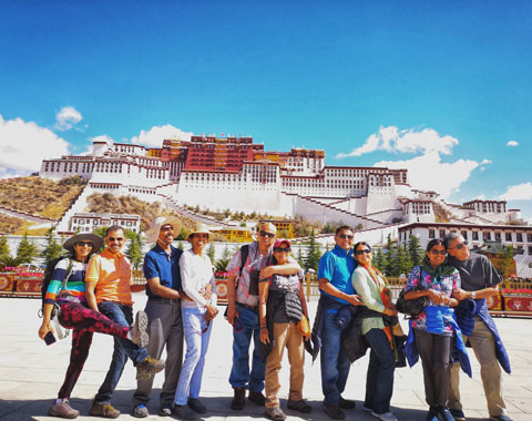
| Lhasa | 3,656 | Lhasa, the world's highest provincial capital at 3,656 meters, boasts a 1,300-year history, symbolized by the revered Jokhang Temple. Nestled in the Lhasa River Valley, surrounded by towering peaks and rivers, it's a cultural treasure. The iconic Potala Palace, perched above, embodies Tibet's rich heritage. |
| Gyantse | 3,977 | Gyantse, at 3,977 meters, is located in the Nyang Chu Valley. It features the well-preserved Gyantse Dzong fort on rocky heights. The town's charm extends to the Kumbum Stupa, a Tibetan marvel at the Pelkor Chode Monastery. This 600-year-old structure stands at 32 meters, housing 108 chapels over nine tiers, topped with a gleaming golden dome. |
| Shigatse | 3,840 | Shigatse, meaning "fertile land" in Tibetan, is located at about 3,840 meters and includes the towering Mount Everest within its jurisdiction. This historic city, Tibet's second-largest, boasts a legacy of over 600 years and is a significant spiritual center. At its heart lies the Tashilhunpo Monastery, founded in 1447 by the first Dalai Lama and serving as the revered seat of the Panchen Lama. |
| Tingri | 4,300 | Tingri, or Ganggazhen, is a quaint town in Shigatse Prefecture, located at about 4,300 meters above sea level. With a population of fewer than 1,000 residents, it serves as an important stop for travelers heading to Mount Everest along the Friendship Highway. It features landmarks like the ancient Shelkar Dorje Dzong fort and Shelkar Chode Monastery. |
| Gyirong | 2,774 | Gyirong, a border town on the Tibetan plateau, plays a crucial role as the main international gateway between Tibet and Nepal, notably through Gyirong Port. This modern border crossing facilitates tourism, cultural exchange, and economic ties between the two regions, promoting cross-border harmony. |
| Tsedang | 3,500 | Tsedang, near Mount Gongbori, is the cradle of Tibetan civilization, featuring ancient ruins. Yumbulagang Palace, Tibet's first palace, is a historic highlight. Just 30 km west, Samye Monastery, Tibet's first, sits by the Yarlung Tsangpo River, showcasing its rich heritage. |
| Nyingchi | 3,000 | Nyingchi, often called the "Swiss Alps of Tibet," boasts captivating natural beauty, including ancient forests and the stunning Draksum-tso lake. Located in the southeast, it's a popular entry point from Sichuan or Yunnan, offering scenic landscapes for a captivating Tibetan adventure. |
| Nagqu | 4.507 | Nagqu, in northern Tibet, is famed for vast grasslands and traditions. The "Heavenly Lake" Namtso, Earth's highest salt lake at 4,718 meters, offers stunning views. The Nagqu Horse Racing Festival showcases Tibet's culture and is a major event in western China. |
| Ngari | 4,500 | Ngari, in western Tibet, features spiritual and historical sites like Mount Kailash and the Guge Kingdom ruins. Near India and Nepal, it combines natural beauty with rich culture, making it a remarkable Tibet destination. |
| Chamdo | 3,200 | Chamdo, in eastern Tibet, covers 108,600 sq km, bordering multiple provinces. Rawok Lake, in Baxoi County, is a highlight, known for its Swiss Alps-like beauty, offering a serene retreat in Tibet. |
 With an altitude of 3,658m, Lhasa is the spiritual heart of Tibet.
 The iconic Kumbum stupa in Gyantse
Altitudes of All Most Popular Tourist Sites of Tibet
| Attraction | Altitude (meters above sea level) | Introduction |
| Potala Palace | 3,656 | The Potala Palace in Lhasa symbolizes Tibet's high-altitude culture. It was the Dalai Lama's winter residence since the 7th century and is a treasure trove of Tibetan heritage, showcasing its architectural and historical significance. |
| Jokhang Temple | 3,656 | Lhasa's Jokhang Temple, the oldest and holiest in Tibet, houses the revered Jowo Shakyamuni Buddha statue. It's a spiritual center for Tibetan Buddhists who perform rituals like circumambulations. The temple's religious and historical significance makes it a must-visit for all. |
| Sera Monastery | 3,700 | Sera Monastery, one of Tibet's top Gelug monasteries, sits at 3,700 meters near Lhasa. It's known for fostering religious learning and hosts daily monk debates, promoting intellectual discussions on Buddhist doctrines, a unique and culturally rich aspect of Tibetan monastic education. |
| Ganden Monastery | 3,800 | Ganden Monastery, a prominent Gelugpa monastery near Lhasa, sits at 4,300 meters on Wangbur Mountain. It's the birthplace of the Gelugpa school, surrounded by serene mountain vistas. The monastery is a gateway for treks like Ganden to Samye, combining spirituality and adventure. It also offers spiritual retreats amid tranquil landscapes, ideal for deeper exploration of Tibetan Buddhism. |
| Tashilhunpo Monastery | 3,950 | Tashilhunpo Monastery, founded in 1447 by Tibet's first Dalai Lama and situated at 4,000 meters, serves as the Panchen Lama's residence, signifying its vital role in Tibetan Buddhism. This historical monastery epitomizes Tibet's rich monastic traditions, housing precious relics like the colossal gilded Future Buddha statue, underscoring its religious importance. |
| Lake Yamdrok | 4,441 | Lake Yamdrok, one of Tibet's sacred lakes, lies at 4,441 meters altitude, spanning 72 kilometers and 638 square kilometers. Its unique shape and pristine beauty are set against a backdrop of snow-capped mountains, with the Yarlung Tsangbo River valley nearby. To reach this tranquil spot from Lhasa, you'll traverse the towering Gampa La Pass at 4,790 meters. |
| Lake Namtso | 4,718 | Namtso Lake, often known as the "Heavenly Lake," is one of Tibet's "Great Three Sacred Lakes." It's located at an altitude of about 4,718 meters. To get there from Lhasa, travelers can take the road trip and pass through the Nagenla Pass at 5,190 meters, offering breathtaking views. |
| Lake Manasarovar | 4,590 | Manasarovar Lake, also known as Mapam Yumtso, is one of Tibet's Great Three Sacred Lakes, situated at an altitude of 4,590 meters. It holds deep sacred significance in Hinduism and Buddhism. Hindus believe it's where Maya Devi conceived Siddhartha Gautama, the future Buddha. In Buddhism, it's a revered site for pilgrimage and spiritual reflection. Its serene beauty and spiritual importance make it a cherished destination for those seeking both natural and religious experiences. |
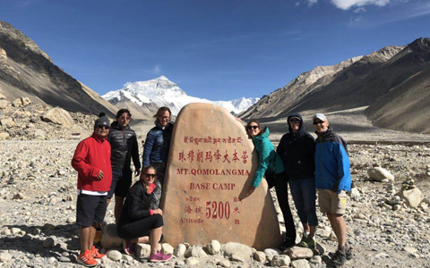
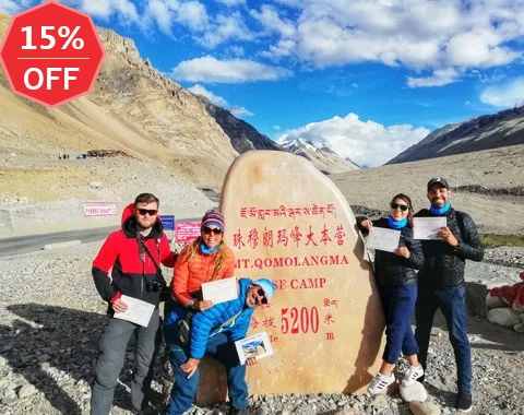
| Everest Base Camp | 5,200 | Everest Base Camp, located at the foot of Mount Everest, serves as a starting point for climbers and a prime spot to witness the world's highest peak. Travelers can reach it overland from Lhasa for scenic Tibet vistas or trek from Old Tingri for a challenging but rewarding journey. Whether you aim to conquer the peak or savor the views, Everest Base Camp is a must-visit in the Himalayas. |
| Samye Monastery | 3,580 | Samye Monastery, Tibet's first Buddhist monastery, founded in the 8th century under King Trisong Detsen, lies about 170km southeast of Lhasa. It's nestled along the Yarlung Tsangpo River, showcasing ancient Buddhist traditions and art. |
| Sakya Monastery | 4,300 | Sakya Monastery, founded in 1073, is a prominent Tibetan Buddhist center near Shigatse. Known for its distinctive grey soil, it's renowned for Tibetan murals, scriptures, and historical relics. It's a hub of Buddhist art and learning. |
| Norbulingka Palace | 3,650 | Norbulingka Palace, Lhasa's Summer Palace for Dalai Lamas, is a cultural center. During the Shoton Festival, it hosts picnics and opera in its gardens. Near the Potala Palace, it's a cherished Tibetan site. |
| Guge Kingdom | 3,889 | Guge Kingdom, an ancient realm in Western Tibet's Zanda County, can be explored starting from Lhasa, passing through Shigatse, EBC, Saga, Mount Kailash via the southern route, and then heading northwest to Guge Kingdom. This journey combines historical and natural wonders for an enlightening and scenic experience. |
 Turquoise Yamdrok Lake in Shannan Prefecture
 The incredible winding road to EBC.
 Heavenly Namtso Lake, the world's highest saline lake
Altitudes of All Most Famous Mountains of Tibet
| Mountain | Altitude (meters above sea level) | Introduction |
| Mt. Kailash | 6,714 | Mount Kailash, or Gang Rinpoche, the holiest mountain in Tibet, is revered in Hinduism, Jainism, Buddhism, and Bonpo. The Kailash Kora pilgrimage starts at Darchen (4,575 meters) and ascends to Dolma La Pass (5,630 meters), blending deep spirituality with stunning natural beauty, attracting pilgrims and trekkers globally. |
| Mt. Everest | 8,849 | Mount Everest, also known as Chomolungma in Tibetan, is the world's highest peak at 8,848.86 meters. The best places to see it are Everest Base Camp, around 5,200 meters high, and Rongbuk Monastery, at about 5,100 meters. |
| Mt. Nyenchen Tanglha | 7,162 | Mount Nyenchen Tanglha, or Nyainqêntanglha Feng, is the highest peak in the Nyenchen Tanglha Mountain Range, reaching 7,162 meters. It's closely located to Lhasa and holds significance in the Nyingmapa Tradition of Tibetan Buddhism, symbolizing the fusion of natural grandeur and spiritual importance in Tibetan culture. |
| Mt. Shishapangma | 8,027 | Mount Shishapangma, Tibet's highest peak at 8,027 meters, is the 14th highest globally and the only 8,000-meter mountain entirely within Tibet. It's known as Gosainthān in Sanskrit and holds a unique position in the Himalayas. Climbers celebrated its conquest as the last of the 8,000-meter summits, highlighting its allure. |
| Mt. Namjagbarwa | 7,782 | Mt. Namjagbarwa, situated in Tibet's southeast, ranks 15th globally at 7,782 meters. It's renowned for its stunning natural beauty within the Great Bend of the Yarlung Tsangpo River. Often veiled in mist and snow, it's lovingly called the 'shy mountain' due to rare clear views, making each sighting a precious moment. |
| Mt. Lhotse | 8.516 | Mount Lhotse, the world's fourth highest peak at 8,516 meters, straddles the Nepal-Tibet border. Its Tibetan name, 'south peak,' hints at its close proximity to Mount Everest, linked by the 'South Col' ridge. In Tibet, Lhotse offers breathtaking views from Nyalam County, Shigatse Prefecture, showcasing its Himalayan grandeur. |
| Mt. Cho Oyu | 8,188 | Mount Cho Oyu, the world's sixth-highest peak at 8,188 meters, rests on the China-Nepal border, 20 km west of Mount Everest. Its Tibetan name, 'Turquoise Goddess,' echoes its stunning beauty. Considered the 'easiest' eight-thousander to climb, its close proximity to Everest enhances its allure in the Himalayan realm. |
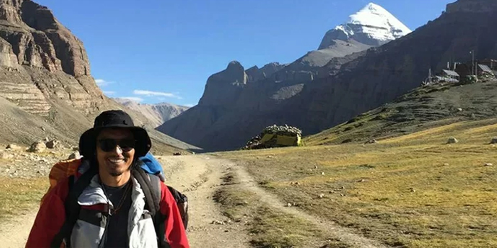
 photographing holy Mt.Kailash, the king of Tibetan mountains
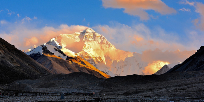
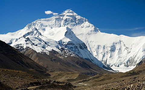
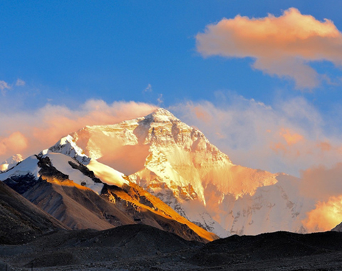
 Mind-blowing vista of Mt. Everest in Tibet at sunset
Altitudes of All Tibetan Areas Surrounding the Tibet Autonomous Region
| Areas | Average Altitude (meters above sea level) | Introduction |
| Kham Tibetan Region in Western Sichuan | 3,500 | The Kham Tibetan Region in Western Sichuan is renowned for its stunning landscapes, encompassing expansive grasslands and towering mountain ranges. This area boasts a plethora of attractions, including Gongga Mountain and Daocheng Yading Nature Reserve. Nestled on the southeastern edge of the Qinghai-Tibet Plateau, Kham offers a remarkable fusion of natural beauty and cultural exploration. |
| Garzê Tibetan Region | 3,390 | The Garzê Tibetan Region mainly covers regions such as Garzê Tibetan Autonomous Prefecture, Ngawa Tibetan and Qiang Autonomous Prefecture, Ya'an City, and Liangshan Yi Autonomous Prefecture in Sichuan Province. It is also part of the Kham Tibetan region in western Sichuan. Garzê Tibetans mainly speak local language, focus on agriculture, and are a significant Tibetan subgroup, sometimes called "Rongba”. |
| Deqen Tibetan Region | 3,294 | Deqen Tibetan Region is situated in the northwestern part of Yunnan Province, near the junction of Yunnan, Tibet, and Sichuan provinces. This region features breathtaking natural landscapes, including high mountains, canyons, lakes, and lush forests. Prominent tourist destinations include Shangri-La, Pudacuo National Park, and Ganden Sumtseling Monastery, among others. |
| Amdo Tibetan Region | 3800 | Amdo Tibetan region is located in the northern parts of Qinghai and Gansu provinces. It's known for its vast grasslands, nomadic traditions, and equestrian culture. The region hosts horse racing festivals like Yushu and Gesar, highlighting Tibetan horsemanship, dance, and music. |
 Daocheng Yading Nature Reserve.
How to Prevent the High Altitude Sickness of Tibet
Exploring Tibet's heights is thrilling but demands caution due to its altitude. Here's a concise guide to ensure safety:
1) Do Medical Check before Departure: Get a physical check-up before traveling to Tibet to flag potential health issues.
2) Prepare Medicines: High altitudes can increase the risk of altitude sickness and cold-related illnesses. Carry essential medications, including those to prevent and alleviate these conditions, in your travel kit.
3) Acclimatization: Begin your journey in lower-altitude areas and gradually work your way up, allowing your body to adjust over several days. So it is recommended to stay a couple of days in Lhasa before heading to EBC or Mount Kailash.
4) Stay Hydrated and Rest: Drink water regularly and avoid exertion until you're accustomed to the altitude.
5) Guided Travel for Added Safety: Consider booking your journey with our experienced guides. They not only provide invaluable insights into the local culture and terrain but are also well-equipped to ensure your safety. In emergencies, they'll guide you to medical services.
Conclusion
Tibet, the 'Roof of the World,' presents a mosaic of altitudes, from towering peaks to expansive plateaus. Each height tells a tale of nature's grandeur and the resilience of its inhabitants. For travelers keen to embark on this unparalleled adventure, the landscapes promise awe-inspiring vistas and profound cultural experiences. Yet, it's vital to tread with respect for the altitude's challenges. Embrace Tibet's majesty, but always prioritize well-being to make your journey both memorable and safe. Happy exploring!

Jamyang Tsering, one of our senior travel guides, has a wealth of experience spanning nearly 20 years. Also a celebrated YouTuber for our Tibet Vista channel, Jamyang is genuinely enthusiastic about showing the REAL Tibet to both our customers and fans. It could be an interesting experience to explore Tibet with Jamyang.
Related Articles & Posts


Most Popular Tibet Tour Packages
-
Lhasa - Gyantse - Shigatse - Everest Base Camp - Shigatse - Lhasa
USD939
View Details -
Lhasa - Gyantse - Shigatse - E.B.C - Saga - Kailash Trek - Darchen - Lake Manasarovar - Saga - Gyirong - Tingri - Lhasa
USD2059
View Details -
10 Days Lhasa to Everest Base Camp and Namtso Lake Small Group Tour
Lhasa - Gyantse - Shigatse - EBC - Shigatse - Lhasa - Namtso Lake - Damxung - Lhasa
USD1289
View Details -
8 Days Driving Across Himalaya Overland Adventure from Kathmandu to Lhasa
Kathmandu - Gyirong - Everest Base Camp - Tingri - Shigatse - Gyantse - Lhasa
USD1069
View Details -
4 Days Lhasa Impression Small Group Tour: Explore the Heart of Tibet and Mingle with the Locals
Lhasa
USD509
View Details -
Lhasa - Gyantse - Shigatse - Everest Base Camp - Gyirong - Kathmandu
USD979
View Details -
Lhasa - Gyantse - Shigatse- Lhasa
USD799
View Details -
13 Day Lhasa, Mt. Everest, Mt. Kailash, Lake Manasarovar and Kathmandu Adventure Tour
Lhasa - Gyantse - Shigatse - EBC - Saga - Darchen - Kailash Trek - Darchen - Saga - Gyirong - Kathmandu
USD2059
View Details