
Burang, the Major Border Linking Ngari to Nepal and India
Bordering Nepal and India, Burang is one of the main three regions of Ngari, in western Tibet. It covers an area of 12,497 square kilometers and has a population of over 8,000 inhabitants. The villages of Burang lie in a valley between the giant Mount Namonanyi and the Abi mountain ranges. Burang, therefore, is known as the region surrounded by snow-covered mountains. Located 398km (247 miles) south of the town of Shiquanhe and only 20km (12 miles) from Sino-Nepal border, Burang lies at a lower altitude than most of Ngari, averaging around 3,900 meters (12,795 feet). This gives it a more hospitable climate and makes it the most favorable environment in the Ngari region for agriculture.
Not only is the county the location of Mount Kailash and Lake Manasarovar, it also borders on Nepal and India to the south, and it is a center for trade with Nepal and India for centuries. It is also the location of the only Himalayan pass from Nepal into China in Ngari prefecture. As a major crossing point into Tibet from Nepal, it is widely used for Nepali and Indian pilgrims heading for Mount Kailash and Lake Manasarovar at the time of the Yatra.
Top Highlights in and around Burang, Ngari Border
While Burang may not be a large area in Ngari, it is home to some of the most amazing sights and attractions in Tibet, many of which are rarely seen by international travelers. This stunningly beautiful area in what is a mostly arid land is an unexpected pleasure for travelers to the area.
Burang International Market
A traditional frontier market, which has a history of more than 500 years, Burang attracts many foreigners to do business here. As a seasonal market, the Burang International Market is open from July 15 to Oct 15 every year. In summer Tibetans, Chinese, Nepalese and Indian traders gather to sell different products from their home countries, including cloth, coffee, and jewelry that are here for sale or to be exchanged for sheep and wool, which will be taken back home before winter comes. During the winter and early spring, the paths and the road to Burang are regularly blocked by heavy snow storms and the region remains in complete isolation.
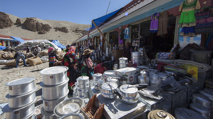 Local Tibetans are purchasing goods at Burang International Market.
Valley of the Karnali River
One of the four rivers that rise from the region of Sacred Mount Kailash in Ngari, the Karnali River, also known as the Ghaghara, is a wild and rapid river as it flows south through Burang County. Rising from an altitude of around 3,962 meters, the river flows straight through Burang Town as it heads south, running across the Sino-Nepal border and on for another 1,080 kilometers to its confluence with the Ganges at Revelganj in Bihar, India. In Burang County, the Karnali River Valley is one of the most fertile valleys in Ngari prefecture, and is a major area of agricultural land for local crops.
Abi Gamin Ranges
Located in the central Himalayas, right on the border between Tibet and Uttarakhand in India, Abi Gamin is the culminating peak of the Zaskar range and the second highest peak in the immediate region. Sitting at 7,355 meters above sea level, the summit of this peak lies directly on the border, with its northern slopes in Burang County. First surveyed in 1848, during the British Great Trigonometric Survey of India, Abi Gamin was not conquered until August 1950 by an Anglo-Swiss team of mountaineers from the southwest ridge route.
Mount Namo Nanyi (Gurla Mandhata)
The highest peak in the Nalankankar Himal, which is a small range of the Himalayas, Namo Nanyi lies in the south of Burang County, close to the border with Nepal and is the 34th highest peak in the world at 7,694 meters above sea level. Known also as Gurla Mandhata, the mountain was named after the former king of the Ikshvaku Dynasty, King Mandhata of Suryavansha. Noted for being one of the few peaks above 7,000 meters that is wholly inside Tibet, its Tibetan name, Naimona'nyi, translates roughly to "the mountain of heaped-up slabs of black herbal medicine."
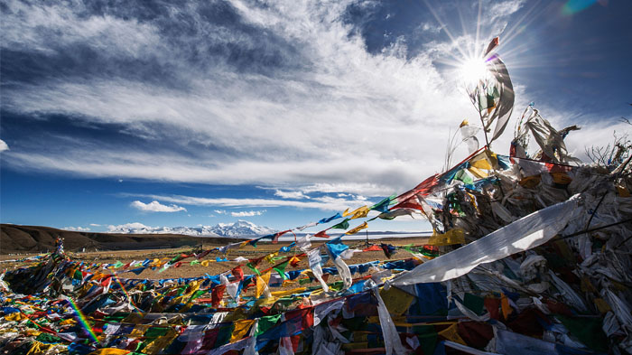 Enjoying the far-distant view of Mount Namo Nanyi
Simbiling Monastery
Set above a ridge of ancient cave dwellings high above the town of Burang, Simbiling Monastery is also known as Shambuling Gompa, Shepeling Dzong and Taklakot Gompa and lay next to the fort of Tegla Kar, also known as the Lying Tiger Fort. This ancient gompa and fort was the last defense of the Dogra forces that attempted to conquer parts of western Tibet in the 1840s, which failed after Tibetan forces drove them back into Ladakh. The original monastery, which had more than 100 rooms and housed several hundred Buddhist monks of the Gelug School of Tibetan Buddhism, was flattened by artillery in 1967, but rebuilding work began in 2003 and continues with several dozen monks now in residence once more.
Khorzhak Monastery
A Kagyu Buddhist monastery in Khorzhak Town in Burang County, Khorzhak Monastery lies just northeast of the Indian border at a bend of the Karnali River. From the small village on the riverbanks, it is easily possible to see the huge red walls of the monastery that face the river, inscribed with the traditional six-syllable mantra, ON MANI PADME HUM. Legend tells that one of the four images of Chenresig was brought to Tibet in the 7th century from Nepal, and when the temple was built, the silver and jade image spoke aloud, telling that it wished to be placed over a fossil in the ground. The temple is said to have been founded in 966 AD by the Burang King, Khor-re and his son, Prince Lha-de. Once one of the most important Kagyu monasteries in western Tibet, the monastery survived the Cultural Revolution almost intact, except for the silver statue that disappeared. All that remains now is the lotus-shaped jade base.
Mount Kailash
Known as the most sacred mountain in the world, Mount Kailash lies close to the source of some of the longest and largest rivers in Asia, including the Indus, Sutlej, Brahmaputra, and Karnali. Held in reverence by four separate religions – Buddhism, Hinduism, Jainism, and Bon – this unique pyramid-shaped mountain of unusual black rock is one of the few mountains in the world that has never and will never be climbed. Held to be so sacred, China has forbidden any attempts to scale its holy slopes, and mortal man has never set foot on the mountain itself. The location of one of the hardest and most arduous treks in Tibet - the Kailash kora - this awesome peak stands a mere 6,638 meters above sea level, and is the highest peak in the Gangdise range.
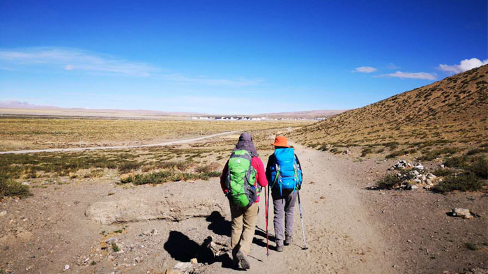 Under the brilliant sunshine, our clients began their epic trekking to Mount Kailash.
Lake Manasarovar
One of the Great Three Sacred Lakes of Tibet, Lake Manasarovar is considered to be the most sacred lake for both Buddhists and Hindus alike. Lying on the Tibetan plateau in Ngari Prefecture, a short distance to the south of Mount Kailash, this stunning lake sits at an altitude of around 4,590 meters above sea level. According to Hindu legends, the lake was first created in the mind of Lord Brahma, and manifested on earth. It is widely believed that those who dink from or bathe in the lake will be absolved of the sins of an entire lifetime. If interested, you can join-in the Manasarovar Yatra with sincere pilgrims.
Lake Lhanag-tso
The twin lake to Lake Manasarovar, Lhanag-Tso is often referred to as Lake Rakshastal, which means lake of the Demon. While Lhanag-Tso is the twin to Manasarovar, and it is believed that they were once one single lake that split apart, this heavily saline lake bears none of the religious significance of its neighbor. As a pair, the lakes are referred to as “brightness” and “darkness”, and the lake has no aquatic plants or fish in its salty waters.
Dining and Accommodation Conditions in Burang, Ngari
Burang County itself has a good number of hotels and restaurants where you can stay and eat whilst in the area, and the hotels range from good-quality 4-star to low-cost budget hostels to suit all requirements. Hotels such as the Himalaya Kailash Hotel, the Ali Pulan Town Hotel, and the Hotel Jeevan Deep are some of the more popular places to stay in Burang.
When it comes to dining, there may be some limitations to the ingredient options in this remote area of Tibet. However, even at this high altitude and remoteness, the typical traditional Tibetan dishes can still be found in every restaurant in Burang. The cuisine in Burang County focuses mostly on the high-calorie foods such as beef, mutton, yak meat, and dairy products such as yogurt, as well as the ever-present tsampa from the highland barley crops of the valley area. While western food may not be present, you can also find some good examples of Indian and Nepali foods in some of the restaurants.
Best Time to Visit Burang County, Tibet
Lying in the far northwest of Tibet, Burang County is best visited from April to June and September to October, when the weather is at its best for travel in the region. Once the bitter cold of winter has passed, the weather warms up in April, and up to June the temperatures continue to rise, leaving the land warm and pleasant to visit.
Summer, from late June to the end of August is the monsoon season, though in this area of Tibet there is very little rain at all. Even in the wettest month of the year, you can expect no more than 25mm of rain for the whole month.
The early autumn is also a great time to travel, after the light rains have gone and left the landscape lush and green. The weather is still warm throughout September and October, and the skies are clear and bright, making it one of the best times to visit Mount Kailash and Burang County.
How to Make Pilgrimage to Mount Kailash from India and Nepal via Burang County
For those that want to make a pilgrimage to Mount Kailash from India and Nepal, it is possible to take the trip direct from Nepal to Burang County, instead of heading to Lhasa first. This allows you to travel into Nepal and cross the border into Burang County at Hilsa, and to return the same way after you have completed your pilgrimage.
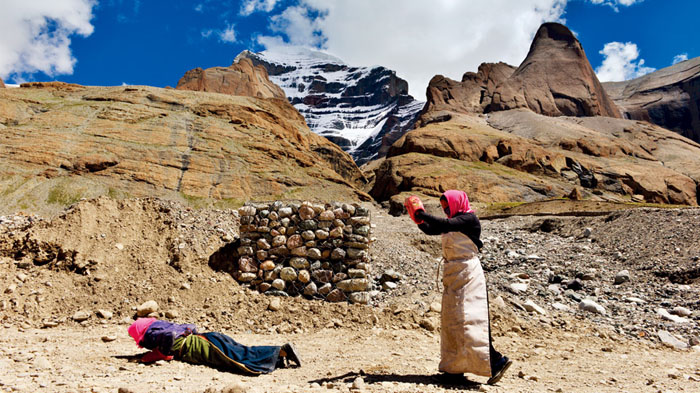 Making pilgrimage along the outer kora of Mt. Kailash
Our excellent tours to Mount Kailash allow you to fly from Kathmandu to Simikot, in northwest Nepal, and then take a short helicopter trip to Hilsa, where you will cross the border over the Karnali River into Burang County of Tibet. You will be met in Tibet by your guide who will take you to the sacred mountain for the pilgrimage, and once you are complete, you will be taken back to Burang to cross back over the border for the helicopter flight to Simikot and the flight to Kathmandu.
Tips:
Considering the increasing altitude and travel cost, you can also join in our 15 days Kailash and Manasarovar group tour or 13 Days Kailash Manasarovar tour via Gyirong Port for pilgrimage.
What travel documents do I need to enter Ngari from India and Nepal via Burang
As with all tours to Ngari Prefecture in northwestern Tibet, you will need to have certain permits arranged prior to traveling there. Tibet is a place where independent travel is not permitted, and all tourists must be on a pre-arranged tour of the region. Once you have booked your tour with us, we will use scanned copies of your passport and visa to make the applications for the permits you will need. The permits for Ngari and Burang County are:
Tibet Travel Permit - This is required for entry to Tibet and to travel around in the area of Lhasa.
Alien’s Travel Permit - Required for travel to the “unopened” areas of Tibet outside Lhasa, including Shigatse.
Restricted Areas Permit - This is often called the “Military Permit”, and is required for travel to military-sensitive areas such as Ngari, Nyingchi, etc.
Frontier Pass - While most tours will not actually cross the border out of China, the Frontier Pass is required for all tourists traveling in the areas of the Chinese border with India, Nepal, and Bhutan, which includes Mount Everest and Mount Kailash.
Chinese Group Visa - For those traveling to Tibet from Nepal, the standard visa does not apply, and you will need the Chinese Group Visa for entry into China, whether by flight or overland. This special visa is not available by personal application, and will be applied for by us on your arrival in Kathmandu, using your original passport. Processing time is just three working days.
For Indian nationals traveling to Tibet, the same rules apply for the visa and permits required when entering from Nepal and China. Normal Indian tourists need to have the Tibet Travel Permit, Alien’s Travel Permit, Chinese Group Visa, etc., before they travel. However, all Indian nationals traveling to Mount Kailash are considered as pilgrims instead of tourists, and are required to arrange their trip through Pilgrim Center for Indian pilgrimage to Tibet.
Conclusion
As the main border county between Tibet and Nepal or India, Burang County is one of the major routes for Indian pilgrims to Mount Kailash, as well as being the home of the world’s most sacred mountain. And with so many sights and attractions in this remote yet beautiful part of the Tibetan plateau, it is well worth spending the time to visit, no matter which route you take to get there.

I am a tour guide in Tibet an was Born in Kham Tibet, I am the father of 2 little girls, bachelor's degree. I have more than 7-years experience of being a tour guide in Tibet. I am a warm, friendly, knowledgeable and attractive guy.

.jpg)


0 Comment ON "Burang, the Major Border Linking Ngari to Nepal and India"