
Map of Chamdo Prefecture, the East Gate to Tibet
Chamdo is one of the six districts of the Tibet Autonomous Prefecture of the People’s Republic of China, and was once a part of the ancient region of Kham. Known as the cradle of the Khamba culture in Tibet, this ancient land was a home to the precursors of the Tibetan people more than 4,000 years ago. The seat of Karub District, Chamdo Town, is the third largest city in Tibet, after Lhasa and Shigatse, and is the location of the stunning Galden Jampaling Monastery, built in the 15th century on the recommendation of the Gelug founder, Je Tsongkhapa.
Qamdo Location Map
Qamdo Prefecture lies in the far east of the Tibet Autonomous Region, on the lower edge of the Tibetan plateau. The prefecture is surrounded by Lhasa to the west, Nagqu to the northwest, Qinghai Province to the north, Sichuan Province to the east, Nyingchi to the south, and the northwest corner of Yunnan Province connecting to the most southeasterly corner of Chamdo.
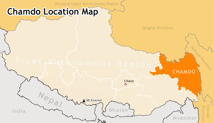 (Simple click to enlarge the map)
Qamdo Location Map
Sitting on the eastern edge of Tibet, Chamdo was part of the route of the ancient Tea Horse Road that stretched across half of China and on into Nepal and India centuries ago. Chamdo has long been the cultural and transport hub of much of the trade that passed through into Tibet in ancient times, and has long been a strategic location as the pivotal connection between Tibet, Yunnan, Sichuan, and Qinghai.
Map of Chamdo and Surrounding District and Counties
Chamdo Prefecture-level city is actually divided into 11 county-level divisions, which are made up of one district and ten counties. The main district is known as the Karuo District, while the counties include Jonda County, Gonjo County, Riwoche County, Dengqen County, Zhag’yab County, Baxoi County, Zognang County, Maarkam County, Lhorong County, and Banbar County.
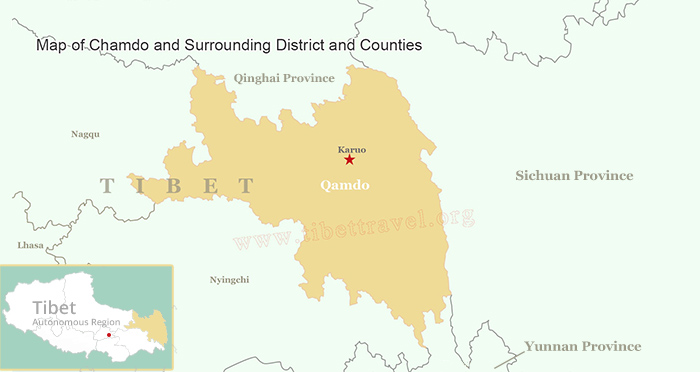 (Simple click to enlarge the map)
Map of Chamdo and Surrounding District and Counties
Karuo District, also known as Chamdo County, Qamdo County, and Chengguan, is a county in the east of the Tibet Autonomous Region, and the seat of government of Qamdo Prefecture. Chamdo literally means “river confluence” in Tibetan and usually refers to the city of Chamdo straddling the Mekong River at the point where its Ngom-chu and Dza-chu tributaries converge.
Chamdo County covers an area of 10,700 sq km and has a population of over 90,000, of which 90% are Tibetan. Just located along the Sichuan-Tibet Highway, Chamdo is 1,066km away from Lhasa via Nagqu or 1,179km via Kongpo. Chamdo is popular with tourists for the Chambaling Monastery in the capital and the salt mines and hot springs at Yangjing.
Riwoche County is a little known county located in Chamdo prefecture in northern Tibet (Kham). It sits at around 3,400m above sea level and borders Nangchen to the north, Chamdo to the east and Dengchen to the west. Its administrative center is located in Riwoche Town. The Dzi River, a tributary of the Mekong River, flows through the region. Most of Riwoche County is farmland, where wheat and barley are grown. Yaks are abundant and they are found throughout the region, grazing on the mountains. Riwoche is heavily wooded with evergreen forests and the Tibetans in this region mostly live in wood-built homes.
Riwoche is a great place to spend a couple of days, though travel to this region is out of reach for most budget travelers. The main attraction in Riwoche is the huge Riwoche Tsuglakhang Temple which is located in the northern part of the county and shaped in a big square. It is unlike any other monastery in Tibet. Prayer wheels, many of which are covered in dried animal skins, are lined all around the 4 walls of the monastery.
Qamdo Attraction Map
Galden Jampaling Monastery: constructed between 1436 and 1444 by Jansem Sherab Zangpo, a disciple of Tsongkhapa, Galden Jampaling Monastery originally contained 5 main temples and housed around 2,500 monks. Destroyed in 1912, this monastery was rebuilt in 1917, and now houses about 800 monks.
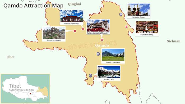 (Simple click to enlarge the map)
Qamdo Tourist Attraction Map
Ranwu Lake (Rawok-tso): Known as Ngan-tso in Tibetan, Ranwu Lake is the largest lake in eastern Tibet, and is fed by numerous streams from the ice and snow melt of the mountains and glaciers that lie on three of its sides.
Lhegu Glacier: a group of glaciers located near Lhegu Village, the name translates to “a hidden village of idyllic beauty”, and it is named because of its location. The glacier, which lies below the Bosura Mountain is made up of the Meixi Glacier, Yalong Galcier, Ruojiao Glacier, Dongga Glacier, Xiongjia Glacier and Niuma Glacier.
Riwoqe Monastery (Riwoche Tsuglhakhang): Founded in 1276, Riwoqe Monastery was originally a subsidiary monastery of the Talung Monastery, and grew to eclipse its parent monastery over the centuries as one of the most impressive monasteries in Tibet.
Kamaduo Stupas: Located to the north of the Ancient Tea Horse Road, the Kamaduo Stupas were built after the Mandala of Amitayus appeared to a disciple of the Red Hat Line of Tibean Buddhism at the place where they now lie.
Wara Monastery: of the main monasteries of Sakya lineage, Wara Monastery is located in Jomda County and is famous for its peacocks, an auspicious bird in Tibetan Buddhism.
Kanuo Ruins (Karub Ruins): The earliest Neolithic ruins discovered in Tibet, the Karub Ruins date back to around 3,300 BCE, and show evidence of civilized culture on the plateau long before the modern-day Tibetans moved into the region.
Zezhol Monastery: One of the best preserved Bon monasteries in Tibet, Zezhol Monastery lies on Zezhol Mountain, and is more than 3,000 years old, and is a legendary site of the preaching of Buddhism in Tibet by Amitabha, who is said to have preached to the Bon people of the area there.
Banda Grassland: At an altitude of more than 4,000 meters, the Banda Grassland is a wide and beautiful wilderness of grassy plain, without a tree in sight, that stretches for miles, with its local population of nomadic Tibetan herders.
Attractions around Chamdo on Map
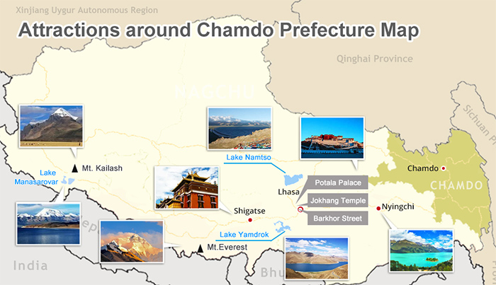 (Simple click to enlarge the map)
Attractions around Chamdo on Map
Qinghai Lake: Also known as Kokonor, Qinghai Lake is the largest lake in China, and is renowned for its famous Bird Island, a year-round migration site for birds from the north of China in the winter and from the south in the summer.
Xinduqiao: A small and peaceful Tibetan town in western Sichuan, not far from Kangding, Xinduqiao is renowned for being one of the best places for nature photography in the world, with an average elevation of around 3,500 meters.
Shangri-la: Previously known as Zhongdian, Shangri-La is a small primeval Tibetan town about 5 hours north of Lijiang in Yunnan Province. Renamed after the legendary Shangri La, from the novel Lost Horizons, this small town lies in some of the area’s most outstanding natural countryside.
Lulang Forest: At an elevation of around 3,700 meters, the Lulang Forest is a natural host of many of the genetic materials of the plants that can be found all across Asia. Known locally as the “place that will make you forget home”, this stunning landscape is a fairyland of the gods.
Potala Palace: Built in the 15th century on the site of an 8th century fortress, the Potala Palace was designed to be the center of government in Tibet by the Dalai Lama, and lies in the center of Lhasa, on the top of the famous Red Hill.
Namtso Lake: Known as the “Heavenly Lake”, Namtso is one of the Great Three Sacred Lakes of Tibet, and one of the most beautiful places on the plateau. Isolated throughout the winter, the islands of the lake were once used as a summer hermitage.
Qamdo Weather and Temperature Chart
Chamdo has a continental plateau climate that is characterized by two distinct seasons, wet and dry, as well as having relatively low temperatures. The rainy season runs from May to September, while the dry season runs from October to April. Due to its complex geography, Chamdo climate can vary from place to place, with cooler drier weather in the north and northwest, and hot wet weather in the southeast. The average temperature in this region is around 8 degrees centigrade, with an average temperature of -2.8 degrees centigrade in January and 16 degrees centigrade in July. The average precipitation is 467 mm per year.
| Jan | Feb | Mar | Apr | May | Jun | Jul | Aug | Sep | Oct | Nov | Dec | |
| Ave temp (℃) | -2.8 | 0.7 | 4.5 | 7.9 | 12.2 | 15.2 | 16 | 15.3 | 12.8 | 8.2 | 2.8 | -2 |
| Monthly Rainfall (mm) | 1.2 | 4 | 9.6 | 23 | 39.2 | 85.2 | 100.2 | 96.8 | 76.1 | 31.3 | 5.5 | 2.4 |
| Days of rainfall per month | 2.2 | 3.1 | 5.7 | 10.9 | 13.2 | 17.9 | 19.7 | 18.1 | 17.8 | 9.6 | 3.2 | 1.7 |
Ancient Tea Horse Roads to Chamdo Tibet Map
Sichuan Tibet Highway Northern Route G317
One of the major routes from Sichuan Province to Lhasa, the G317 is the northern route of the Sichuan Tibet Highway, and the more scenic of the two routes. The route follows the National Highway G317 from Chengdu to Lhasa, passing through Dujiangyan, Danba, Dege, Chamdo and Nagqu, before dropping down to the Tibetan capital, a distance of 2,412 kilometers.
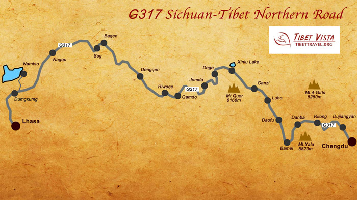 (Simple click to enlarge the map)
Sichuan Tibet Highway Northern Route Map
Sichuan Tibet Highway Southern Route G318
The southern route of the Sichuan Tibet Highway follows the G318 from Chengdu to Lhasa and beyond, and is the main route from Sichuan Province to the Tibetan plateau. The route starts in Chengdu and takes you to altitudes above 5,000 meters, heading through Ya’an, Xinduqiao, Markam, Basu, Bomi, and Nyingchi, entering Lhasa from the east.
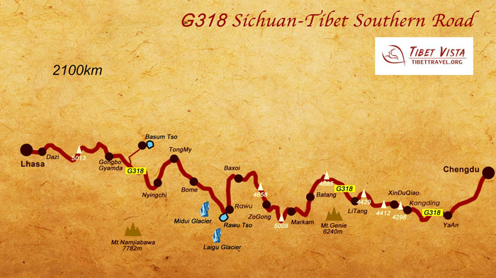 (Simple click to enlarge the map)
Sichuan Tibet Highway Southern Route Map
Yunnan Tibet Highway G214
Starting in Kunming in Yunnan Province, the G214 route takes you north, heading through the Hengduan Mountains and Shangri La to meet up with the G318 Sichuan Tibet Highway at Markam. Once a major part of the ancient Tea Horse Road, the Yunnan Tibet Highway has some of the best mountain views in southwest China.
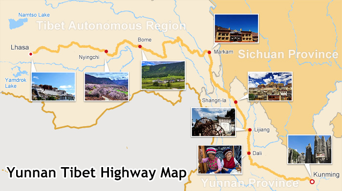 (Simple click to enlarge the map)
Yunan Tibet Highway Map
Map of Flights to Qamdo Bamda Airport
One of the five airports that have been built to cater to domestic flights to Tibet from mainland China, the Chamdo Bamda Airport is located on the western bank of the Yuqu River, in a narrow valley on the Banda grasslands. At an altitude of 4,334 meters above sea level, it lies just 136 kilometers from Chamdo Town and is rated as the airport with the worst weather in the world.
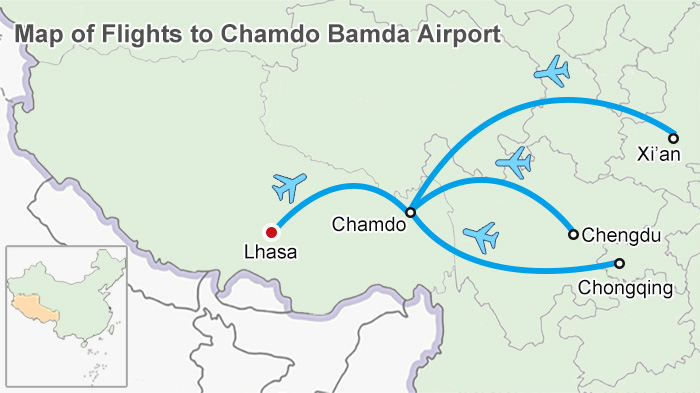 (Simple click to enlarge the map)
Map of Flights to Qamdo Bamda Airport
Flights to Bamda Airport are run by Air China and Tibet Airlines, and fly from Chengdu, Chongqing and Tianjan, as well as flights from Lhasa. However, the airport is not open to international tourists, so travelers need to fly in to either Lhasa or Nyingchi airports.

My Name is Chloe, Senior Trip Advisor for Tibet trip with 5 years working experince in Tibet tourism. Loving Tibet, loving all beautiful thing around.A great funs of nature, with piercing eyes to find beauty in both Nature and People. Patient, Warm Hearted , Considerate, Easy- going , Knowledgeable and always ready to offer help to some one in need.

.jpg)


0 Comment ON "Map of Chamdo Prefecture, the East Gate to Tibet"