
Lhasa to Kathmandu Overland: road condition from Lhasa to Kathmandu
Generally speaking, the roads from Lhasa to Kathmandu are pretty good and well constructed. And it is instantly obvious that the roads in Tibet are in far better condition than those in Nepal. Not only are the roads smoother but there are also safety barriers around all the bends.
So, even it is not so straightforward, it is a safe and smooth road. On the Chinese side, most of the road is paved except for the side trip to EBC, for which 4WDs are needed. The paved roads in Tibet run right up to the new Sino-Nepal border crossing at Gyirong Port. It is only once you get into Nepal, and take the roads down from Rasuwa Gadhi, that you will find narrow dirt and gravel roads that are in poor condition. These conditions do improve in the lower sections of the valley, and after you exit the Langtang National Park heading for Kathmandu, the road is paved for the rest of the trip.
Normal vehicles can easily run on these tarred roads. Only to those remote mountain areas, such as during the Everest Base Camp tour from Tingri to EBC, 4WD land cruisers will be used for the rougher road surfaces.
Road Condition from Lhasa to Kathmandu
Road Condition from Lhasa to Shigatse
The road from Lhasa to Shigatse, which is just one short section of the vast Friendship Highway from Lhasa to Nepal, runs for around 271 kilometers from the Tibetan capital to Tibet’s second city. As one of the most driven roads in Tibet, this stretch of the G318 National Road travels along the Kyi Chu Valley for around 60 kilometers, to where the Kyi Chu joins the Yarlung Tsangbo River at Quxu. From there, the road continues to the west, following the valley of the Yarlung Tsangbo River through Nyemo County and Rinbung County to Shigatse. A relatively level stretch of road that follows the river valleys, this easy and fast stretch of the Friendship Highway is the easiest stretch of the main highway.
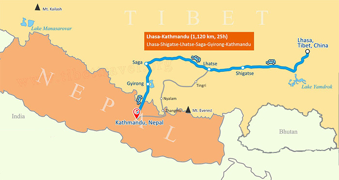 The road map from Lhasa to Kathmandu
For tours in Tibet, many of them take the offshoot road that turns off the main Friendship Highway at Quxu, heading southwest to cross the high Gampa La Pass at 4,794 meters, and dropping down to run along the northern shores of Lake Yamdrok. The pass gives tourists one of the best panoramic views of the lake possible, and as it continues towards the town of Gyantse, runs along the northern shores of the lake. After passing through the town of Nagarze, it heads west towards Gyantse, 263 kilometers from Lhasa. Gyantse is a popular tourist town and is the site of the most amazing stupa in the region, the Gyantse Kumbum. Standing 32 meters tall, this unique stupa is the only one of its kind in Tibet. After Gyantse, the road turns northwest and heads on to Shigatse, a distance of around 356 kilometers.
Road Condition from Shigatse to EBC
Far in the west of Tibet lies one of the most popular tourist attractions in the world. Known locally as Qomolangma or Chomolungma, the world’s highest mountain, Mount Everest, sits placidly on the border between China and Nepal. Hundreds of thousands of visitors make the journey across the plateau to the northern base camp every year, and the site is easily accessed by road from Lhasa or Kathmandu.
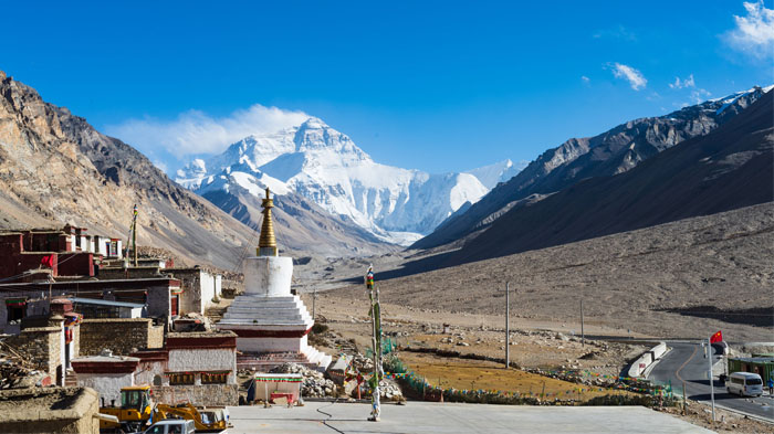 The well-paved asphalt road leading to Rongbuk Monastery
From Shigatse, the road continues along the G318 Friendship Highway to the town of Old Tingri, and the road is asphalt for the entire distance. At Old Tingri, the route to Everest Base Camp (EBC) turns south, and heads along the smaller and more winding Zhufeng Road to get to the famous base camp at the foot of the world’s highest mountain. The road condition of this stretch of the route from Shigatse varies, with some sections being new asphalt while others are still the original gravel roads. Work still continues to upgrade these gravel sections to asphalt, and it is expected to be finished soon, making the entire trip smoother and faster.
As the crow flies, the straight-line distance from Shigatse to EBC is around 235 kilometers, a relatively short distance on this vast plateau. However, the driving distance from Shigatse, traveling through Lhatse and Tingri to the base camp near the Rongbuk Monastery is actually a huge 342 kilometers. This long drive, thanks to the better road conditions, now only takes a mere 6-7 hours, which can be done in one day.
Road Condition from EBC to Gyirong Border
Starting from the famous Everest Base Camp in Tibet, the route to take to get to Nepal, crossing at the new Gyirong port border crossing, takes you back along the Zhufeng Road to Old Tingri, a distance of 75 kilometers along the Zhufeng Road back to the Friendship Highway. From Tingri, the route once more follows the G318, as far as Nyalam County in Shigatse, where the route turns off the Friendship Highway, as the road to Nepal via Zhangmu is no longer open.
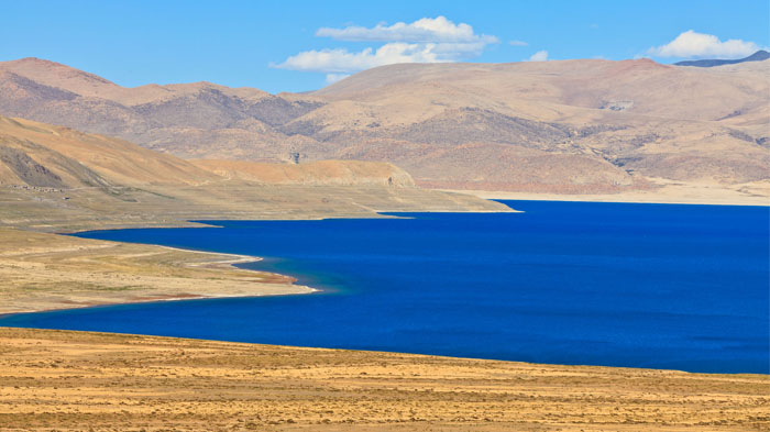 Right beside the highway to Gyirong Country lies the enchanting Paiku co Lake
The distance to Nyalam County from Tingri is around 74 kilometers, and this is where the route turns onto the S214 National Road, which takes you all the way to the border. Passing through Nyalam County and into Gyirong County, the road heads past three stunningly beautiful small lakes, Baikumai Co, Langqiang Co, and Paiku Co, before looping round to head south to Gyirong Town, which lies just 24 kilometers from the Sino Nepal border. The total distance from Nyalam to Gyirong is around 185 kilometers, and from EBC, while the direct distance is just 152 kilometers as the crow flies, the total drive of 330 kilometers is a full day of driving.
As with the route along the Friendship Highway, the section of road from Nyalam to Gyirong is also asphalt for the entire distance, and has helped to make the long journey to this new border crossing into Nepal much easier and faster. The final stretch of road from Gyirong To the border is also asphalted, and the trip takes just 30 minutes on the last day of the tour in Tibet.
Road Condition from Gyirong Border to Kathmandu
The route from the border crossing at Gyirong Port heads across the Resuo Bridge, the new bridge that spans the Trishuli River Gorge, and takes you on into the Nepali border checkpoint of Rasuwa Gadhi. Here you will process your visas, before heading out to the parking lot to arrange or meet your transport to Kathmandu.
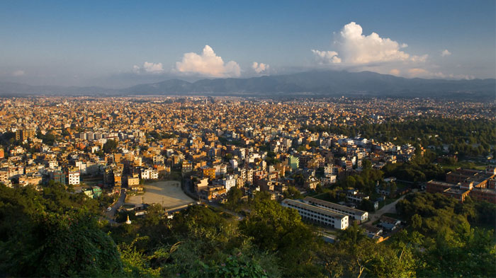 Final part of the road to lively Kathmandu Valley from Sino-Nepal border
The complete distance from the border at Rasuwa Gadhi to Kathmandu is around 160 kilometers, and you can travel the route by bus, shuttle, or private car. The only difference here is cost and comfort, as all the means of transport take around the same time to get to the Nepali capital.
The conditions of the road to Kathmandu vary, and while the road has been paved for the entire distance now, there can still be patches of muddy roads in some stretches near the Langtang National Park in the rainy season. Once you have dropped down from the mountains, the road conditions improve, and the route is clean and paved all the way to Kathmandu.
Most Favorable Seasons and Road Condition for Lhasa to Kathmandu Overland Tour
Spring and autumn are the best times to travel along the road from Lhasa to Kathmandu, and the road conditions are usually dry and clean, making the trip fast and easy, with very few problems along the way. Summer, which is the peak season in Tibet, is also a good time to travel, as the well-paved roads in Tibet make driving easier in the wetter weather, though care should still be taken as wet roads can be slippery.
>> Check When Is the Best Time to Tour Tibet and Nepal Together?
Worst Seasons and Road Condition for Lhasa to Kathmandu Overland Tour
In summer, once you cross into Nepal, the heavier rains can often make the roads wet, muddy, and dangerous, and greater care should be taken traveling down from the border to the lower regions of Nepal and the Kathmandu Valley.
In winter, the roads can get a little icy from Shigatse to Gyirong Port, and some of the passes may see snow in the depths of winter, making the journey a little treacherous. However, it is still possible to drive all the way from Lhasa to Kathmandu in the winter months, as the well-paved roads make travel easier. Once across the border, where the temperatures are not so cold, the roads are less likely to be slippery, though care must be taken on the first stretch of road from Rasuwa Gadhi to Syabrubesi.
Join-in Most Popular Lhasa to Kathmandu Overland Tours
Conclusion
The road from Lhasa to Kathmandu is one of the most epic journeys in the Himalayas and across the Tibetan plateau, and can actually be done at any time of the year, with a little care in the wet and wintry seasons. The total distance from Lhasa to Kathmandu by road is around 1,112 kilometers, or 607 kilometers as the crow flies.

With exceptional passion and outstanding leadership, Mrs. Catherine has dedicated herself to Tibet inbound tourism and China tour for 15 years. As one of the handful females who see great potential of Chinese inbound tourism, Catherine has made great contribution to promoting Tibet tourism and enhancing the employment of Tibetans and prosperity of local Tibetan community.
Over the years, she travelled overseas with Tibet Tourism Bureau many times to promote Tibet tourism. Currently, Catherine works as the marketing director of Tibet Vista, an opinion leader behind the whole team of Tibet Vista.

.jpg)


0 Comment ON "Lhasa to Kathmandu Overland: road condition from Lhasa to Kathmandu"