Everest Base Camp Trekking Maps in Tibet
Mount Everest (8844.43m), the main peak of the Himalayas, is located in the southeast of the Sino-Nepal border with base camp on both sides. The south camp in Nepal is situated at an altitude of 5,364 meters, while the north Tibetan camp is slightly lower at 5,150 meters. Since the north base camp is much easier to be accessed, Tibet Everest Base Camp has become one of the most popular mountain destinations in the world. Tibet Vista has made a collection of EBC trekking maps for you to plan an unforgettable trek to the world's highest peak.
Old Tingri to Everest Base Camp Trekking Map
Old Tingri to Everest Base Camp trek is one of the most popular trekking routes in the world. In this adventurous trip, you can finish the 70-km-long hiking route in four or five days with the elevation vary from 4400m to 5200m. The whole journey starts from Old Tingri, and then pass through Ra-chu Valley to Lungthang, Lamna La Pass, Zommug, Rongbuk Monastery and finally get to the destination - Everest Base Camp.
According to our Everest travel experience, we suggest you to get up as early as 6:00am for the stunning sunrise over Mt.Qomolangma. And one day is enough for you to capture the breathtaking scenery at Everest area.
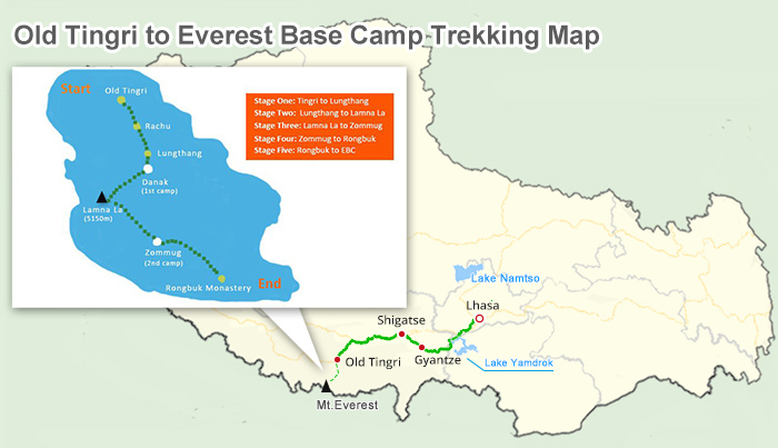 (Simple click to enlarge the map)
Old Tingri to Everest Base Camp Trekking Route on Map
Trekking Route: Old Tingri (4390m)- Ra-chu Valley - Lungthang (4510m) - Lamna La Pass (5150m) - Zommug (4790m) - Rongbuk Monastery (5100m) - Everest Base Camp (5200m)
Start: Old Tingri (4390m)
End: EBC (5200m)
Highest Point: EBC (5200m)
Distance: 70km trekking
Duration: 4-5 Days
Best Time: May to October
Difficulty: Medium to difficult
Permits: Tibet Entry Permit, Alien's Travel Permits, Frontier Pass
Accommodation: Camping
Food: Self-sufficient
Join-in Tibet Everest Base Camp Trekking Tours
Gama Valley to Eastern Slope of Mt. Everest Base Camp Trekking Map
Located between Dingri County and Dingjie County, Gama Valley, the most beautiful valley in the world, spans from Chengtang (2200m) westward the eastern slop of Mt.Everest (8844.43m) and extends from Nangma-la pass (5344m) southward Makalu Barun National Park (8025m). With the altitude ranging from 2000m to 8000m, the 55-km-long Gama Valley is home to various fauna and flora, a vast land of virgin forest and majestic glaciers.
And the most exciting thing in Gama Valley to Everest trek is to enjoy the spectacular views of the snow-capped Himalayan Mountains in such a close distance, including Mt.Everest (world first, 8844.43m), Mt.Lhotse (world fourth, 8516m), Mt.Makalu (world fifth, 8485m), etc. Tourists usually start their trek from Youpa to Eastern Slope of Mt.Everest Base Camp through huge cypress trees, wetlands and lakes with beautiful azaleas scattering along the route.
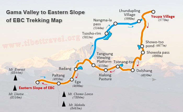 (Simple click to enlarge the map)
Gama Valley to Eastern Slope of Mt. Everest Base Camp Trekking Route on Map
Trekking Route: Youpa Village (3770m) - Showo-tso pond (4677m) - Showola pass (4900m) - Dolshang (Orchid valley, 4030m) - Tsonang-tso - Xialong Pasture - Tangsung Viewing Platform (4510m) - Badang - Ega - Paltang (4950m) - Eastern Slope of Mt.Everest Base Camp (5310m) - Paltang (4950m) - Ega - Tangsung Viewing Platform (4510m) - Tsosho-rim (5013m) - Nangma-la pass (5344m) - Lhundupling Village (3990m)
Start: Youpa Village (3770m)
End: Lhundupling Village (3990m)
Highest Point: Nangma-la pass (5344m)
Distance: 111km trekking
Duration: 8-9 Days
Best Time: April to June and September to October
Difficulty: Medium to difficult
Permits: Tibet Entry Permit, Alien's Travel Permits, Frontier Pass
Accommodation: Camping
Food: Self-sufficient
Join-in Tibet Everest Base Camp Trekking Tours
Everest Base Camp to Advanced Base Camp Trekking Map
Everest Base Camp to Advanced Base Camp trek is highly-reputed as the highest trek in the world. Unlike hiking from Old Tingri to EBC and ascending the summit of Mt.Everest, EBC to ABC trek is an alpine expedition that offers ordinary tourists a real chance to get closer to Mount Everest and appreciate the unique landscape under the premise of safety.
Starting from Everest Base Camp (5200m), tourists usually trek along the moraine piles besides Rongbuk Glaciers to Interim Camp (5760m) and then move upwards along East Rongbuk Glaciers to Advanced Base Camp (6500m). In the 38-km-long expedition, you can not only enjoy a long unique cultural landscape of Tibet but also penetrate into the Himalayas Ranges and experience the hardships as well as pleasure to climb Mount Everest.
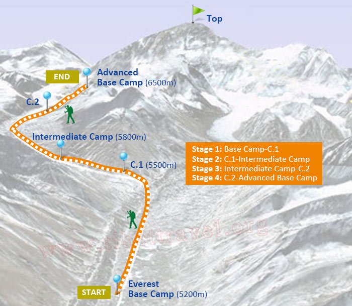 EBC to ABC Trek Map
Trekking Route: Everest Base Camp (5200m) - Camp 1 (5460m) - Interim Camp (5760m) - Camp 2 (5970m) - Advanced Base Camp (6500m) - Camp 2 (5970m) - Everest Base Camp (5200m)
Start: Everest Base Camp (5200m)
End: Everest Base Camp (5200m)
Highest Point: Advanced Base Camp (6500m)
Distance: 38km trekking
Duration: 5 Days
Best Time: April to May and September to October
Difficulty: Difficult
Permits: Tibet Entry Permit, Alien's Travel Permits, Frontier Pass, Tibet Trekking Permit
Accommodation: Camping
Food: Self-sufficient
Join-in Tibet Everest Base Camp Trekking Tours
To majority of ordinary tourists, there is no need to worry about EBC trek in Tibet. All our Tibet Everest Base Camp Tours are safe enough for our clients to handle. Wanna take an expedition to Mt. Everest from Nepal side? Here comes Ultimate Everest Base Camp Trekking Maps in Nepal.
More Mount Everest Base Camp Travel Guide
 Mt.Everest Fact
- Everest Base Camp Nepal vs Everest Base Camp Tibet
- Mount Everest History and Its Famous Explorers
- The Difference of Mt.Everest in Nepal and Tibet
- Kathmandu to EBC Distance: how far and how to get to EBC in Nepal and Tibet from Kathmandu
- How Many Base Camps on Everest in Both Sides of Tibet and Nepal
 Everest Base Camp Tour Guide
- When is the Best Time to Visit Tibet Everest Base Camp in 2024
- When is the Best Time to Enjoy EBC Trek in Nepal
- The Best Hotel at Everest Base Camp in Tibetan Side
- Guide to Tibet Everest Base Camp Tour in Winter
- How to Get to Everest Base Camp (EBC) from Nepal?
- How to Get to Mount Everest Base Camp from Lhasa
- What Documents Do I Need for Everest Base Camp Tour in Tibet and Nepal?
 Everest Trekking Guide
- What to Pack for Everest Base Camp Trek
- Tingri to Everest Base Camp Trekking
- Everest Trek: Trekking Routes along The Gama Valley
- Everest Base Camp Trekking Maps in Tibet
- Ultimate Packing List for Everest Base Camp Trek in Tibet
- Best Trek in Nepal: Everest Base Camp Trek vs. Annapurna Circuit Trek
- Top 2 EBC Trekking Routes in Tibet
- EBC Trek in Tibet vs. EBC Trek in Nepal

Recommended Everest Base Camp Tour Packages
-
 7 Days Lhasa to Kathmandu Overland Small Group Tour: Traverse from the North Side to the South Side of Mt.Everest for the Best of the Himalayas
Tour Route: Lhasa - Gyantse - Shigatse - Everest Base Camp - Gyirong - Kathmandu
From USD979 p.p
-
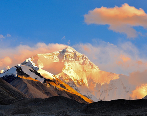 8 Days Lhasa to Everest Base Camp Small Group Tour: Marvel at Mt.Everest Real Close from 4 Different Viewing Platforms
Tour Route:Lhasa - Gyantse - Shigatse - Everest Base Camp - Shigatse - Lhasa
From USD939 p.p
-
 10 Days Lhasa to Everest Base Camp and Namtso Lake Small Group Tour
Tour Route:Lhasa - Gyantse - Shigatse - EBC - Shigatse - Lhasa - Namtso Lake - Damxung - Lhasa
From USD1289 p.p
-
 17 Days Nepal Everest Base Camp Trek Tour
Tour Route:Kathmandu - Phakding-Namche Bazaar-Tengboche- Dingboche- Lobuche-Gorakshep- Everest base camp-Kathmandu

.jpg)



0 Comment ON "Everest Base Camp Trekking Maps in Tibet "