
Where is Bhutan located on a Map?
Bhutan is one of the most unique countries in the world, and when it comes to tourism, even their tourist policies are unique. Dedicated to giving the best quality tourist experiences possible, tourism in Bhutan is eco-friendly and environmental, with only tour operators from the kingdom itself allowed organizing and operating tours to the country. Lying in the southern range of the mighty Himalayas, this popular destination is one of the best locations in the world for unique trekking experiences. And the world’s hardest trek, the Snowman Trek, lies within its borders. But few people actually know where Bhutan is.
Where is Bhutan Located on a Map?
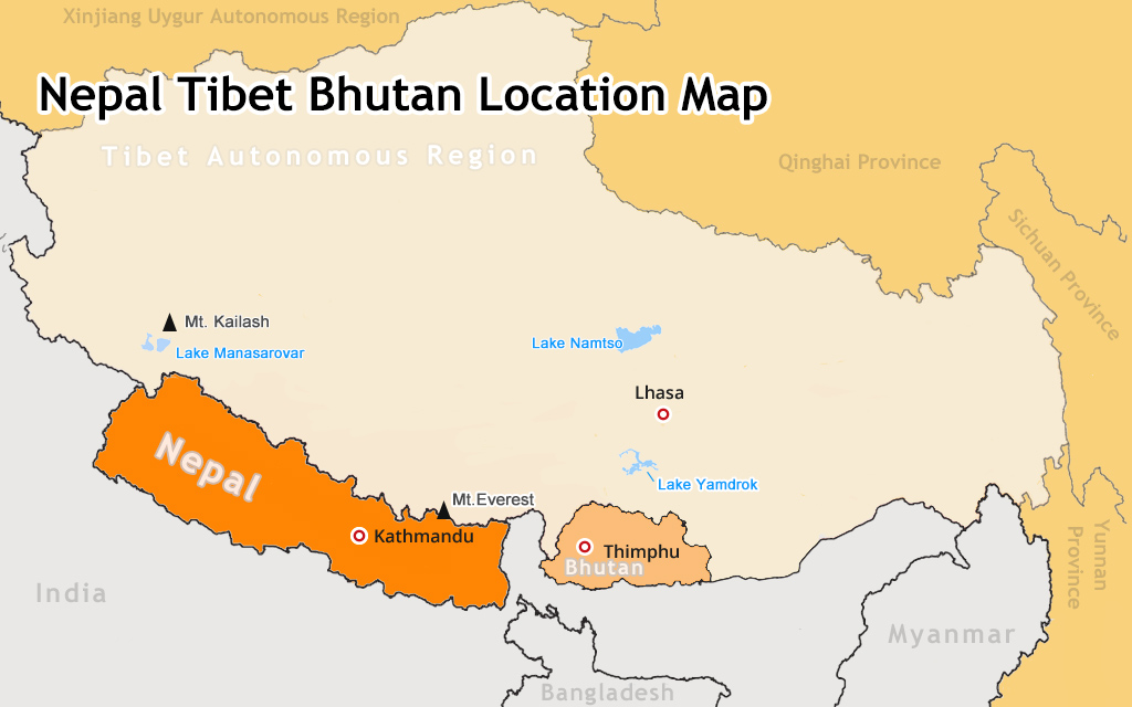 Bhutan Location on a Map
Capital city: Thimphu, the capital of Bhutan, lies in the western central part of the kingdom, and is the largest city in the country. Lying in its own valley, known as the Thimphu Valley, it is also one of the many Dzongkhags or Districts of the country. Thimphu replaced Paro as the capital in 1955, and was made official by the King of Bhutan in 1961.
Administrative divisions: The Dzongkhag is a district division in Bhutan, and each district has its own administration and judiciary, all answering to the central administration in Thimphu. There are 20 separate Dzongkhags in Bhutan, each of which is further divided into smaller counties known as “gewogs”, with 205 gewogs across the kingdom.
Total area: A relatively small country, in comparison with most of its close neighbors, Bhutan is a landlocked nation, covering around 38,394 square kilometers, or around 14,824 square miles. With one of the smallest populations per square kilometer in the world, Bhutan has a government policy of maintaining at least 65-70 percent of the country as woodlands or forests at all times.
Population: Bhutan has a population of around 800,000 people as of the end of 2016. Since no census has been conducted since, any increase in population can only be estimated. The nation has a literacy rate of around 60 percent, and women outnumber men by only around 7 percent. The kingdom consists of three main ethnic groups, the Ngalops of Western Bhutan, the Sharchops of Eastern Bhutan, and the Lhotshampa of Southern Bhutan.
Bordering countries: Bhutan is a landlocked country, and is surrounded by only two other nations; the Tibet Autonomous Region of China lies to the north, with the Chumbi Valley of Tibet lying to the northeast, the Indian State of Arunachal Pradesh to the east, and the Indian States of Assam and West Bengal to the south.
Religious belief: A majorly Buddhist country, around 75 percent of the country follows the state religion of Vajrayana Buddhism, which was introduced to Bhutan in the 7th century from Tibet. With about 22 percent being Hindu, the remaining three percent is split between Bon, Christian, and Islam, and other minor religions.
Languages: The national language of Bhutan is Bhutanese, known locally as Dzongkha, and is one of the 53 Tibetic languages of the Himalayas. Traditional script in Bhutan is known as Chhokey, or Dharma Language, though while Dzongkha is taught as the national language, English is the main medium of instruction in all schools. However, there are also another 22 languages spoken across the kingdom, mostly dialects of the original Dzongkha, but which also includes Nepali. Other dialects include Tshangla, Dzala, Limbu, Keng, and Rai, which make up for around 45 percent of the spoken languages in Bhutan.
Geography: Bhutan is a country of differing altitudes, with the high Himalayas lying in the north of the kingdom and the low-lying plains to the south. With an average elevation of around 2,500 to 3,000 meters, the highest point of the kingdom is the summit of Mount Gangkhar Puensum, at 7,580 meters, while the lowest point is at Drangme Chhu, at just 97 meters above sea level.
Economy: The currency of Bhutan is the “ngultrum”, and the value is linked to the Indian Rupee, with the rupee accepted as legal tender in the kingdom as well. With one of the world’s smallest economies, the national economy is growing rapidly, increasing at an annual growth rate of around 22 percent.
This unique growth, rated as the fastest growing economy in the world, is mainly due to the huge Tala Hydroelectric Power Station, located on the Wangchu River, which sells hydroelectric power to India. The main livelihood of the population is agriculture, which makes up for around 55 percent, 22 percent given to industry, and with only around 1.8 percent attributed to tourism.
Uniquely, Bhutan is the first country in the world to ban the sale of tobacco products under its Tobacco Act of 2010. However, while the sale is prohibited, the use is not, though it is frowned on in most places and there are designated smoking areas for tourists.
Staple food: Bhutanese cuisine mainly consists of red rice, buckwheat, and maize, which is increasing in use and popularity in recent years. Pork, beef, chicken, lamb, and yak meat are also eaten and the famous soups and stews of Bhutan are often made from meat and dried vegetables, spiced with chilies, and with added cheese.
Most of the dishes in Bhutan are very spicy, with a heavy use of hot chilies in most foods. Dairy foods, including butter, milk, and yogurt, from yaks and cows, is a daily staple for most Bhutanese, while the most popular beverage is tea, in the sweet Tibetan form as well as the traditional Tibetan butter tea.
>> Know more about Bhutan and Bhutan Tourism Maps
Bhutan Map with Surrounding Countries
Bhutan is primarily enclosed between China and India, with around 477 kilometers of its borders shared with Tibet and around 659 kilometers with the Indian States of Arunachal Pradesh, Assam, West Bengal, and Sikkim. The kingdom’s other close neighbors include Nepal to the west of the kingdom, Bangladesh to the south, and Myanmar, to the southeast.
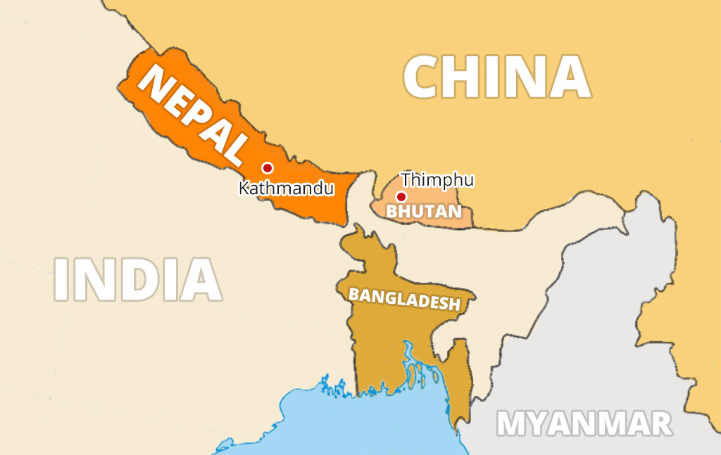 Bhutan Map with Surrounding Countries
Bhutan Lofty Mountains: Gangkhar Puensum (7541 m), Jitchu Drake (6989 m), Jomolhari (7326 m), Zonpghu Gang (Table Mountain, 7100 m), Kangri (7230 m), Masagang (7165 m), etc.
Bhutan lies on the southern edge of the eastern Himalayas, bordering with Tibet on the northern side, and the kingdom is home to several high mountains that reach more than 7,000 meters.
The highest of the many mountains is Mount Gangkhar Puensum, which at 7,570 meters is the world’s highest unclimbed mountain. Since mountaineering is currently banned in Bhutan, and climbing mountains over 6,000 meters has been prohibited since 1994, the mountain is likely to remain unclimbed.
Rivers of Bhutan in Asia: There are four major river systems in Bhutan, and while none of them are major rivers in Asia, all four do flow out of the kingdom to join the Brahmaputra River in India, before it enters Bangladesh to become the Ganges.
Culture Influence: Culturally, Bhutan has been majorly influenced by Tibet, mostly for the influx of Tibetan Buddhism in the 7th century, which was taken as the main religion of the kingdom. Many other things from Tibet have influenced the culture of Bhutan over the centuries, and the modern traditions are deeply steeped in its Buddhist history.
>> Know more about Bhutan Border Map/Bhutan Map with Surrounding Countries
Join-in Most Popular India Nepal Tibet Bhutan Tours
Bhutan Location Map in Asia
Listed as part of Asia, Bhutan is a country in what is regionally known as South Asia, although many people are unaware of this. Asia, being made up of Russia as well, is one of the largest continents in the world, and in relation to the whole of Asia, Bhutan lies in the center of the southern part of the continent. With China to the north and east, India to the west, and the Indochinese area of Southeast Asia to the southeast, Bhutan is surrounded by a variety of Asian nations of different demographic origins.
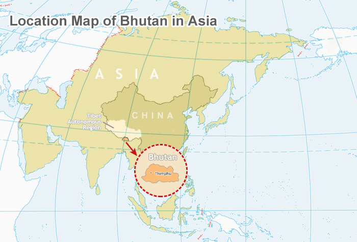 (Simple click to enlarge the map)
Bhutan Location on Asia Map
Bhutan Location on World Map
Geographically, Bhutan lies in the center of the southern area of the Asian Continent, on the northern edge of the Indian Tectonic Plate. Lying between the latitudes of 26.71 degrees north and 28.33 degrees north, and the longitudes of 88.77 degrees east to 92.13 degrees east, Bhutan is a nation of ecological stability that is unmatched anywhere in the world. With the lowest carbon footprint in history, which is actually a negative carbon footprint, Bhutan is an environmentalist’s dream location.
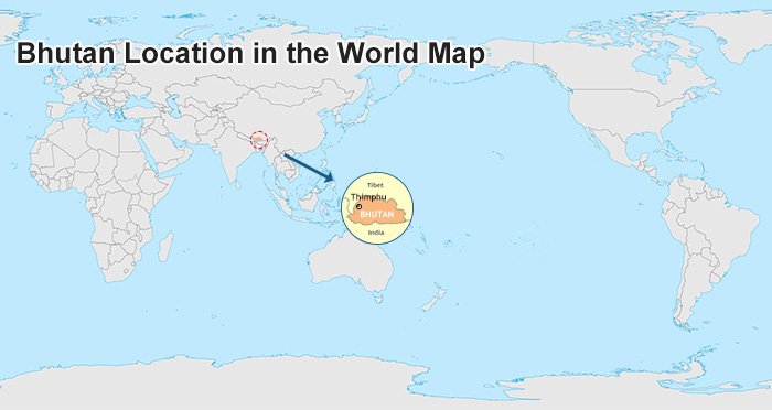 (Simple click to enlarge the map)
Bhutan Location on World Map
Bhutan Map on Google Earth
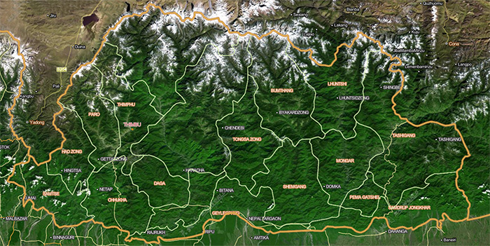
Looking at Bhutan from the perspective of Google Earth, which is the best way to view a satellite image of the kingdom, it is easy to clearly see the change of altitudes across the country, from north to south.
 (Simple click to enlarge the map)
Dense Forest-covered Bhutan on Google Earth
The high mountains of the northern border, covered in snow, can be clearly defined, with the heavily wooded areas clearly shown south of the mountains. The defining elevations are also clear, and the descending landscape can be seen easily as the image shows the lowlands of Bhutan with its hilly landscapes and long valleys.
Bhutan Outline Map
 (Simple click to enlarge the map)
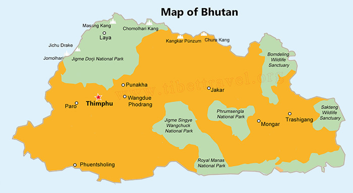
Map of Bhutan Outline
An irregularly shaped country, unlike its close neighbor Nepal, it is clear to understand why its northern border is shaped so, as it lies on the range of the Himalayas, following the contours of the mountain range as it runs from west to east. The southern, western, and eastern borders of the kingdom are mainly defined by the demographics of the population of the kingdom, and are based on the areas in which the native peoples of Bhutan originated.

The Lhasa-born prodigy used to study business overseas, and got his Bachelor of Business in Nepal and India before moving back to his homeland. With pure passion for life and unlimited love for Tibet, Kunga started his guide career as early as 1997.
Responsible, considerate, and humorous, he devoted his entire life to guiding and serving international tourists traveling in Tibet. As a legendary Tibetan travel guru with 20-year pro guide experience. Currently, he is working in Tibet Vista as the Tour Operating Director. Whenever our clients run into trouble, he is your first call and will offer prompt support.

.jpg)


0 Comment ON "Where is Bhutan located on a Map?"