
Maps of Nagqu Prefecture-level City, Northern Tibet
Nagqu Location Map: where is Nagqu located?
Nagqu is a prefecture-level city that is located to the north of Lhasa, in northern Tibet. Officially established as a prefecture-level city in May 2018, it is the sixth prefecture-level city to be established in the Tibet Autonomous Region, with only Ngari still being a separate prefecture. Translated literally as “black river”, Nagqu is bordered with the Xinjiang prefectures of Bayingolin and Hotan to the north, the Qinghai prefectures of Haixi and Yushu and Chamdo Prefecture-level city of Tibet to the east, Ngari Prefecture to the west, and Nyingchi, Lhasa, and Shigatse to the south.
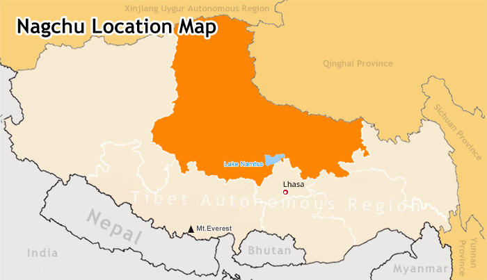 (Simple click to enlarge the map)
Nagchu Location Map
Nagqu City and Surrounding Districts and Counties
The largest of all the prefecture-level cities in Tibet, Nagqu covers more than 450,000 square kilometers and has a population of around 460 thousand people, mainly Tibetans. The city is made up of 10 counties and 1 district. Seni District is the seat of Nagqu, and the location of Nagqu Town, as well as 11 other towns and townships. The remainder of the counties in Nagqu are: Lhaari County, Biru County, Nyainrong County, Amdo County, Xainza County, Sog County, Baingoin County, Baqên County, Nyima County, and Shuanghu County.
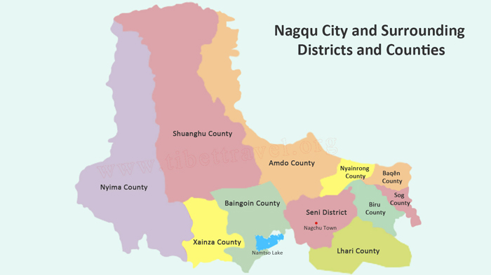 (Simple click to enlarge the map)
Nagchu City Map
Nagchu Attraction Map
One of the areas of Tibet that is rarely visited by international tourists, the prefecture-level city has an abundance of amazing attractions across the area, many of which are some of the most beautiful areas of Tibet, and often only seen from the windows of the train on its way to Lhasa.
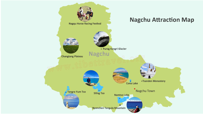 (Simple click to enlarge the map)
Nagchu Tourist Attraction Map
Nagqu Lake and River
Nagqu River: The headwater of the Nujiang River that runs through China to eventually become the Salween, the Nagqu River starts from the small lake near Lake Cona, known as Ganong Lake. The Nagqu River is one of the major water sources of Amdo County, and the river flows out of the southern end of the lake.
Namtso Lake: One of the Great Three Holy Lakes of Tibet, Lake Namtso lies on the boundary between Lhasa and Nagqu, in Damxung County of Lhasa and Baingoin County of Nagqu. The largest lake in Tibet, this stunning body of water is the highest of the Great Three, at an altitude of 4,718 meters above sea level.
Tangra Yum Tso: Lying in the southwest of Nyima County of Nagqu, at around 4,530 meters above sea level, Tangra Yum Tso is a holy lake of the Bon religion, and the fourth largest Salt Lake in China. Located in the lonely Wenbu wastelands of Tibet, one of the most uninhabited areas of the plateau, a small village of Wenbu lies on the shores of the lake, one of the most remote villages in the region.
Siling Tso: Located in Zhongba County, Siling Tso is counted as the highest lake in the world, with an altitude of around 5,386 meters above sea level. This beautiful freshwater lake, in a land of saline lakes, is also the second largest lake in Tibet, right after Lake Namtso.
Cona Lake: At an altitude of around 4,600 meters above sea level, Cona Lake is located in Amdo County of Nagqu, to the west of the Qinghai Tibet Highway between the towns of Nagqu and Amdo. Considered as a holy lake in Tibet, it is believed to be the "soul lake" of the Razheng Living Buddha.
>> Nagqu Lake and River: top five lakes and rivers in northern Tibet
Nagqu Grassland and Natural Wonder
Changtang Plateau: The largest area of grassland plateau in the world, the Changtang Grasslands of the Changtang Plateau stretch for more than 1,600 kilometers from Qinghai right across the region to the border. The second largest nature reserve in the world, the Changtang Plateau has an average elevation of around 4,700 meters.
Nagqu Horse Racing Festival: The most magnificent horse racing festival in Tibet, the annual Nagqu Horse Racing Festival is held on the beautiful grasslands of the Changtang every summer in August, and lasts around 5 to 15 days.
Nyenchen Tangula Mountain: The highest peak in the Nyenchen Tanglha Range, at 7,090 meters above sea level, Mount Nyenchen Tangula lies in the middle of the 600-kilometer-long mountain range in central Tibet that divides the Yarlung Zangbo River from the Changtang Plateau.
Drolma Canyon: Around 90 kilometers from Nagqu Town lies the stunning Drolma Canyon Scenic Area, with an average elevation of around 4,700 meters. Just 11 kilometers to the west of the Qinghai Tibet Highway, the canyon is around 15 kilometers long and is backed by lofty snow mountains, and has a verdant floor with a bubbling creek and plenty of foliage and wild animals.
Shenzha Nature Reserve: Located in Shenzha County of Nagqu, the Shenzha Nature Reserve is a paradise for birds and is the largest protected area for the black-necked cranes in Tibet. Lying in a wide basin in the Changtang Plateau area, the nature reserve sits at an average altitude of around 4,700 meters above sea level.
Purog Kangri Glacier: With its ice field covering an area of more than four hundred square kilometers, this unique glacier has more than 50 tongues spreading out from its core in all directions. The third largest icefield in the world, after the Arctic and Antarctic, this makes it the largest glacier in the world outside the poles.
Geladandong Serac: A vast ridge of ice that tops the peaks of the highest mountain in the Nyenchen Tanglha Range in Nagqu, the Geladandong Serac is the source of the Yangtze River, and lies at an altitude of around 6,621 meters above sea level.
Nagqu Monastery and Cultural Relics
Tsanden Monastery: Located at the top of the Yaleduo Hill in Nagqu, at an altitude of 4,100 meters above sea level, the Tsanden Monastery was built in 1668 as an affiliate monastery of the Drepung Monastery in Lhasa. It even looks similar to the Potala Palace in its design, and is known as the "small Potala".
Relics of Xiangxiong Kingdom: In the west of Tibet there once existed a kingdom known as Xiangxiong, which means "land of the roc", a mythical bird of Middle Eastern origin. Flourishing before the rise of the Tubo Kingdom in the 7th century, the Xiangxiong Kingdom had ties with the Tang Dynasty of China, and occupied most of what is now the Tibet Autonomous Region due to their military might. After being conquered by the Tubo kings in the 8th century, all that remains of this ancient kingdom are a few ruins.
Skeleton Wall: One of the strangest sites in Tibet, the unique Skeleton Wall that lies in the Dodoka Monastery in Biru County is undoubtedly one of the most macabre sights in the world. Made from the skulls of those who are given a sky burial at the monastery, the wall extends around the southern part of the courtyard, and contains thousands of human skulls.
>> Check more details of Nagchu tourist attraction
Attraction around Nagqu City on Map
Potala Palace: Lying on the top of Moburi, at an altitude of 3,956 meters above sea level, the stunning Potala Palace looks down on the city like a guardian spirit. Built in the 17th century as the seat of governance in Tibet, it was later revamped as the winter palace of the Dalai Lama, after the move of the government offices to Norbulingka in 1755.
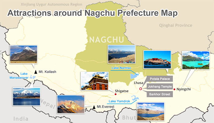 (Simple click to enlarge the map)
Attraction around Nagchu Map
Yamdrok Lake: One of three Sacred Lakes in Tibet, along with Lake Namtso and Lake Manasarovar, Lake Yamdrok lies to the southwest of Lhasa City, in Lhokha Prefecture, at an altitude of 4,441 meters above sea level. Shaped like a Chinese character and believed to be the guardian lake of Tibet, it is believed that if the lake dries up, then Tibet will no longer be habitable for mankind.
Mt.Everest Base Camp: The iconic site of all Tibet, Mount Everest Base Camp, known as EBC, is the northern base camp of the two that exist on the lower slopes of the world’s highest mountain, and was the first base camp to be set up in the 1920s. At an altitude of 5,200 meters above sea level, the base camp is one of the highest tourist spots in Tibet, and the best place in the world from which to get a great photo of the mountain.
Mt.Kailash and Manasarovar Lake: Lying in the west of Tibet, in Ngari Prefecture, Mount Kailash is the world’s most sacred mountain, with a summit that lies at 6,638 meters above sea level. Unclimbed since the days of Milarepa, the Buddhist master, the mountain is a sacred site for Buddhists, Hindus, Jains, and the Bonpo. To the south lies the sacred lake of Manasarovar. At 4,590 meters above sea level, this lake is one of the highest in the world, and is probably he most sacred, as it is revered in four religions. For the Buddhists, it is believed to be the place where Maya Devi conceived Buddha, and in Hinduism, it is believed that bathing in or drinking the waters of the lake can cleanse the sins of an entire lifetime.
Taklamakan Desert: Lying in the southwest of the Xinjiang Uyghur Autonomous Prefecture, to the northwest of Tibet, the Taklamakan Desert covers the whole area from the Kunlun Shan in the south to the Tian Shan in the north. The desert is unique in that, in the colder months, the temperatures can get as low as -20 degrees, while in the summer, it can reach temperatures as hot as more than 40 degrees, and is the only desert in the world to have been completely covered in a layer of snow, in 2008. The average elevation for the desert is around 1,200 meters.
Qinghai Lake: At 3,260 meters above sea level, the Qinghai Lake is not the highest lake in the world, but it is the largest lake in China, and lies in the east of Qinghai Province of China, on the boundary of Hainan and Haibei Autonomous Prefectures, around 100 kilometers west of Xining City.
Galden Jampaling Monastery: Built in the 15th century, the Galden Jampaling Monastery was actually suggested by Je Tsongkhapa in 1373, when he visited Chamdo. Located on the high mesa at the confluence of the three rivers, Ongqu, Zhaqu, and Lacang, the monastery lies at an altitude of around 3,200 meters above sea level.
Lulang Forest: An alpine meadow in Nyingchi County of Nyingchi prefecture-level city, the Lulang Forrest lies at an altitude of around 3,700 meters, and is one of the most beautiful areas of southeastern Tibet. Known as the "a place that will make you forget home", the forest lies to the side of the famous Sichuan Tibet Highway, and is a fairytale land where the gods live in scenic beauty.
Nagqu Climate and Weather Map
Nagqu is an area of Tibet that has a distinct climate, with two main seasons, wet and dry. The monsoon season runs from May to September, and the dry season runs from October to March. Lying within a sub-arctic frigid zone on the Tibetan plateau, the area is prone to extremes of wind and dry air, and can be stormy at times in the summer months. The land is in a permanent state of permafrost, with the frozen ground rarely defrosting for more than the top few inches in the summer. Summer temperatures rarely get above 15 degrees, and in the winter, temperatures can drop to as low as -21 degrees in January. - Best Time to Visit Nagchu: Nagqu climate, weather and horse racing festival
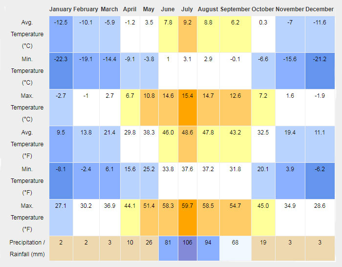 Nagqu Weather by Month
Nagqu Hotels and Restaurants on Map
Nagqu has a wealth of accommodation and restaurants that are suitable for tourists traveling to the area, and which are well worth visiting. Not all the restaurants serve only Tibetan food, though it is a great place to try out the unique dishes of the Tibetan plateau, and you can get Chinese cuisine in many places throughout the area. And while accommodation may not be up to the 5-star hotels that you can find in Lhasa, it is comfortable and clean, with wi-fi and hot running water in most hotels.
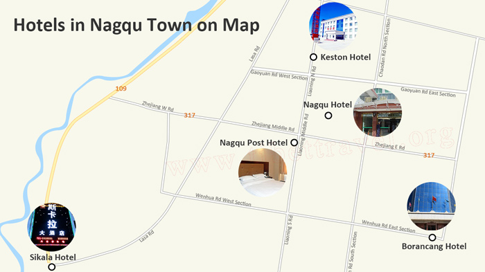 (Simple click to enlarge the map)
Nagchu Hotels on Map
Borancang Hotel: One of the newest hotels in Nagqu, the Borancang has good high-quality rooms and free in-room Wi-Fi.
Location: Crossing of Wenhua Road and Luobu Redi Road, Seni District
Nagqu Hotel: One of the best hotels in Nagqu, the Nagqu Hotel has good clean bathrooms and comfortable accommodation, with hot running water for showers and a choice of rooms with either western or squat toilets.
Location: No.23, Zhejiang Middle Road, Nagqu
Keston Hotel: The Keston Hotel has a gift shop and newsstands, a picnic area, and room service during daytime hours. Wireless Internet access is available at a surcharge, and parking is available on-site for a fee.
Location: No. 57 Liaoning North Road, Nagqu
Nagqu Post Hotel: Providing hot water for baths and shower, and with a constant electrical supply, the Post Hotel is one of the best hotels for good discounts.
Location: Intersection of Zhejiang Road & Liaoning Road, Nagqu
Sikala Hotel: Part of the Aba Motels group of hotels in China, the Sikala Hotel is a modern hotel in Nagqu with clean ensuite bathrooms in all rooms, free Wi-Fi, and a small restaurant that serves traditional Tibetan and Chinese cuisine.
Location: No. 1 Tongzhan Roads, Nagqu
>> Nagchu Food and Drink: best guide to dining in Nagchu
>> Nagchu Hotels and Accommodation: where to stay in Nagchu
Roads to Nagqu Map
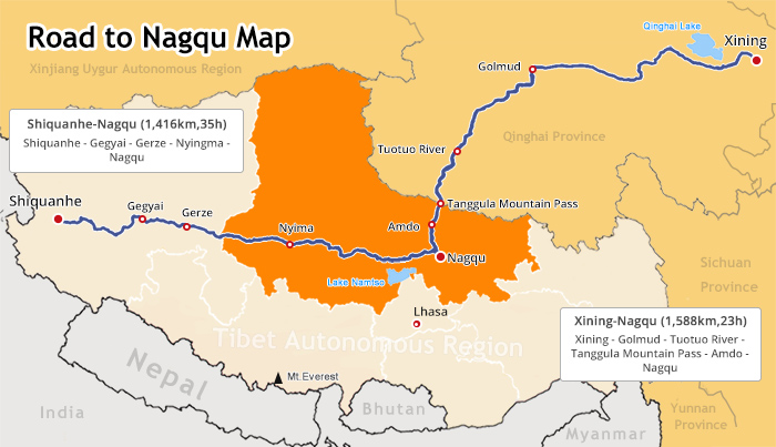 (Simple click to enlarge the map)
Nagchu Roads Map
Qinghai Tibet Highway (Xining to Lhasa Road via Nagqu)
The most used route to get to Nagqu, the Qinghai Tibet Highway is the main route to get to Nagqu by road. The route can be taken in either direction, from both Lhasa and Xining, though the drive from Xining to Nagqu is long and arduous. The route from Lhasa runs through Yangpachen and Damxung County, heading north to the plains of the Changtang Grasslands, and passing through some of the most stunning landscapes in Tibet, as well as passing near to the holy Lake Namtso.
Northern Tibet Highway (Shiquanhe to Nagqu Road)
An immense journey that takes around 36hrs to complete, the road across the north of Tibet from Shiquanhe to Nagqu is 1,412 kilometers in length, and runs across the most desolate part of Tibet. Winding its way across Ngari Prefecture and western Nagqu, the route is one that is not for the faint-hearted, and while it is shorter than traveling first to Lhasa and then up to Nagqu by more than 200 kilometers, it actually takes around ten hours longer if driving continuously.
Nagqu Railway Station and Tibet Train to Nagqu on Map
Nagchu Railway Station lies just alongside 109 National Road, known as the Qinghai Tibet highway, as it runs through the town. One of only a few stations with a crossing loop, the station is a passenger terminal and goods siding, for the transport of food and goods products into the Nagqu area of Tibet. The station at Nagqu can be reached from both Xining and Lhasa by train. - Check the latest schedule of Tibet train to Nagchu
Nagqu Dagring Airport, the World’s Highest Airport in Future
While not yet constructed, the Nagqu Dagring Airport is the planned sixth airport of Tibet, that is intended to serve the Seni District of Nagqu. Once completed, if it is built, it will become the world’s highest airport, at an altitude of around 4,436 meters above sea level, taking the title from the Daocheng Yading Airport in Sichuan Province.

The Lhasa-born prodigy used to study business overseas, and got his Bachelor of Business in Nepal and India before moving back to his homeland. With pure passion for life and unlimited love for Tibet, Kunga started his guide career as early as 1997.
Responsible, considerate, and humorous, he devoted his entire life to guiding and serving international tourists traveling in Tibet. As a legendary Tibetan travel guru with 20-year pro guide experience. Currently, he is working in Tibet Vista as the Tour Operating Director. Whenever our clients run into trouble, he is your first call and will offer prompt support.

.jpg)


0 Comment ON "Maps of Nagqu Prefecture-level City, Northern Tibet"