
Where is Lhasa: how can I find the holy Lhasa City on map and get there?
Where is Lhasa on map? How to get to Tibet Lhasa from my country? As for the first comers to Lhasa, most of you would be confused about the exact Lhasa location. No worries. We have prepared a series of Lhasa maps to make it super easy for you to visit the holy city in Tibet.
Check the helpful maps below, including Lhasa location map, map of Lhasa surrounding districts and counties in Tibet, map of Lhasa surrounding cities and prefectures in Tibet, map of Tibet Lhasa and surrounding provinces in China, map of Tibet Lhasa and surrounding countries in Asia, map of Lhasa location in the world, Tibet Lhasa flight map, Tibet Lhasa train map, Tibet Lhasa road map.
Where is Lhasa Located?
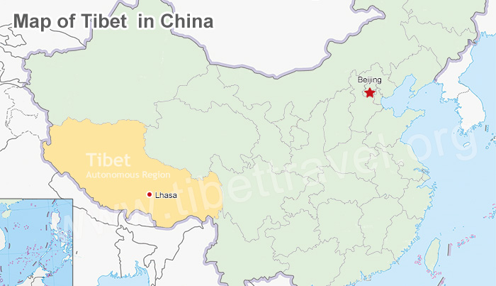 (Simple click to enlarge the map)Map of Lhasa Location in China
.jpg) (Simple click to enlarge the map)Map of Lhasa Location in Tibet
(Simple click to enlarge the map)Map of Lhasa Location in Tibet
Prefecture-level city: Lhasa, capital of Tibet Autonomous Region, China
Administrative divisions: Lhasa Chengguan District, Doilungdêqên District, Dagzê District, Damxung County, Lhünzhub County, Maizhokunggar County, Nyêmo County, Qüxü County (totally with 3 districts, 5 counties, and 64 towns and townships)
Total Area: 29,517.83 km², 277 kilometers from east to west, 202 kilometers from north to south
Time Zone: China Standard (UTC+8)
Average Altitude: 3658 meters above the sea level
Climate and weather: semi-arid monsoon with over 3000 hours of sunshine every year
Neighboring Cities and Prefectures: Nyingchi, Shannan, Shigatse, Nagqu, Chamdo and Ngari
Lhasa Population: 902,500 (around 80% are ethnic Tibetan and most of the rest are ethnic Han Chineses)
Religious Belief: Tibetan Buddhism (practiced by 99% of Tibetans)
Language: Tibetan Language and Mandarin Chinese
Map of Lhasa Surrounding Districts and Counties in Tibet
Located in the southeastern part of the Tibet Autonomous Region, the city of Lhasa lies on the northern bank in the middle reaches of the Lhasa River, a tributary of the Yarlung Zangbo River. With the geographical coordinates are 91°06’ east longitude and 29°36’ north latitude, Lhasa City's administrative area has spanned from 277 kilometers from east to west and 202 kilometers from north to south, covering a total area of 29,518 square kilometers.
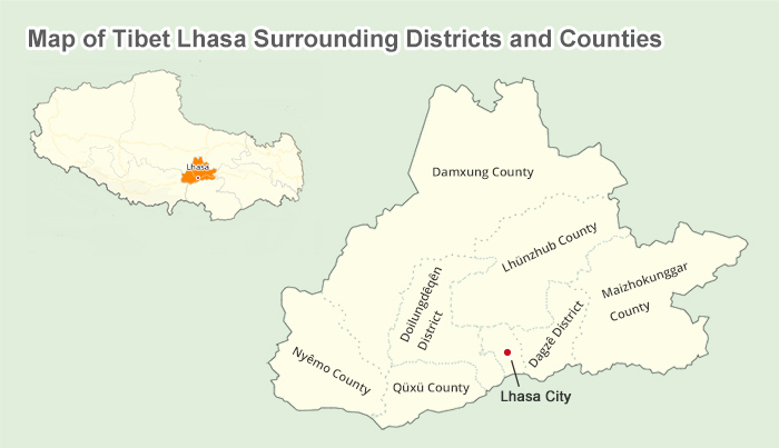 (Simple click to enlarge the map)Tibet Lhasa Surrounding Districts and Counties on Map
As the capital of the Tibet Autonomous Region, Lhasa is the political, economic, cultural, and communication and transportation center for the entire region. Its great position is maintained by the efforts of areas in Lhasa. Administratively speaking, Lhasa is a prefecture-level city that consists of three urban districts and five rural counties in total. Among which, Lhasa Chengguan District is the major tourist destination with top attractions like Potala Palace, Jokhang Temple, Barkhor Street, Sera and Drepung Monastery, etc. Centering on Chengguan District, it’s easy to find Doilungdêqên District, Qüxü County, Nyêmo County, Damxung County, Lhünzhub County, Dagzê District and Maizhokunggar County in a clockwise direction.
Chengguan District
Chengguan District (also Lhasa Urban District) is the main urban area or the city proper of Lhasa, with a total area of 525 square kilometres and a population of 211,400. More 30 nationalities live in this district, including Tibetan, Han and Hui nationalities. 87% of its population are Tibetans. Chengguan means "city pass district" in Tibetan, referring to the city's location nestled between two mountain ridges.
As the proper of Lhasa, this district is also the political, economic and cultural center of Lhasa, even Tibet. The city already has modern industries such as electricity, food processing, construction material, printing, art and handicrafts, etc. The world famous tourist sites like Potala Palace, Jokhang Monastery, Ramoche Monastery, Norbulingka, Drepung Monastery, Sera Monastery and Nechung Monastery are all in this district. Therefore, the hotels in this district are also out of count. For detailed information on the hotels in this district, please refer to Hotels in Lhasa.
Doilungdêqên District
Doilungdêqên District is located in the middle south of Tibet and the middle reaches of the Yarlung Zangbo River, too. This district covers an area of 2,682 square kilometres and has a population of 39,000. It is complicated in landform. Its highest altitude is 5,500 metres while its lowest is 3,640 metres above sea level. Duilong means "legendary" while Dêqên means "the seventh heaven" in Tibetan. It is also rich in mine resources like coal, iron, clay, lead and zinc.
Agriculture in this area is well developed so this district was appointed as the food supply base of the Tibet in 1983. The district also has relatively good transport. Its total road length has reached 270 km and Qinghai-Tibet Highway goes through this county. The most well-known attraction in this county is Tsurphu Monastery that is built in 1189 and regarded as the Region-grade cultural relic reserve.
Qüxü County
Qüxü County is also located in the middle south of Tibet and the lower reaches of the Lhasa River, covers an area of 1,624 square kilometres and has a population of approximately 320,00. Qüxü means "water stream" for there are so many rivers in this area. Meanwhile, there are 14 small power stations and more than 25 bridges in this county, including the widely known Qüxü Bridge which spans the Yarlung Zangbo River and is one of the significant bridges for connecting north and south Tibet.
Qüxü County is also an agricultural area and abundant in mine resources, for example, corundum, calcareousness, granite and turf. The famed tourist attraction, Drolma Lhakhang is located in northeast Qüxü.
Nyêmo County
Nyêmo County is located in the middle south of Tibet and north of the middle reaches of Yarlung Zangbo River, and at an average altitude of more than 4,000 meters above the sea level. It covers an area of 3275 square kilometers and has a population of 28,000. Nyêmo means "wheat ear" in Tibetan. Though it is an agricultural area, it is also plentiful in mine resources, such as copper, molybdenum and turf, and handicraft products including pulu ( a kind of woolen fabric), Tibetan incense, Tibetan paper and potteries. Besides, it is also convenient in transportation for the Sino-Nepal Friendship Highway runs across this area.
Damxung County
Damshung County is also located in the middle of Tibet and by the side of the Holy Lake of Namtso. Damshung means "selected pasture" in Tibetan. It covers an area of 10036 square kilometers and has a population of 38,000. It is at the area of Gangdise Mountains and Nyainqentanglha Mountain. The Nyainqentanglha Mountain and the Qinghai-Tibet Road run through the whole county. Therefore, it is rich in mine resources, including sulfur, kaolin, pozzolana, plaster, turf, and so on. Its industry is mainly animal husbandry which is booming in this county. You can see crowds of yaks, sheep, goats and horses wandering or running on the grassland.
With the development of its economy, the transportation becomes more convenient. The mileage opened to traffic has reached more than 1625 kilometres. Besides, one of the world wonders, Qinghai-Tibet Railway runs through this area. 45% of the famous Namtso Holy Lake is in this county. This lake is the biggest lake in Tibet and covers an area of 1920 square kilometres. Moreover, the world famous Yanpachen Geothermal Power Plant and the Yangpachen Hot Spring are also in this county. When you visit this sites, you can spend the night in the Yampachen Guesthouse.
Lhünzhub County
Lhünzhub County covers an area of 4517 square kilometres and has a population of 540,000. Lhünzhub means " a place from nature" in Tibetan. It is located at the middle of Tibet Autonomous Region and the upper reaches of Lhasa River and splited into two parts by a branch range of the Nyainqentanglha Mountains.
The northern part is mainly composed of mountain and at an average altitude of 4160 metres above sea level. Besides, it is very cold in the northern part. While the southern part is wide and flat. Most of the southern part is used as farmland and pastures. The famous ancient Reting Monastery is in north Lhünzhub and built in 1056.
Dagzê District
Dagzê District (Dagzê means "Tiger Mountains") is also located in the middle south of Tibet, the middle reaches of Lhasa River and at the valley of the middle reaches of Yarlung Zangbo River. It covers an area of 1370 square kilometers and a population of 25,000. Mountains occupy its southeast and northwest areas with an average altitude of 5500 metres above sea level. But its inland part is flat land used as farmland.
The Sichuan-Tibet Road runs through this county, which contributes to the transportation of this area. The district has various animal and plant species, for instance, roe, fox, lynx, caladium and aweto, and all kinds of handicrafts. The world famous monastery, Ganden Monastery in this district attracts numerous international tourists each year for its long history of 600 years. Another well-known tourism spot, Drak Yerpa Meditation Caves, is also located in this county.
Maizhokunggar County
Maizhokunggar County is located at the valley of the middle reaches of the Yarlung Zangbo River, too. It is named after the Maizho King who has lived in this place. Though its average altitude is above 4000 metres, the transportation has been well developed. There are more than 70 roads in this county, including the Sichuan-Tibet Road. Its total road length reaches 650 kilometers.
Its economy greatly contributed by its rich mine resources, silver, copper, lead, zinc, marble and calcareousness, and so on, and the handicraft products like potteries, butter tea bottle, firepan and wine pot. The mystical celestial burial ground is in the famous Drigung Til Monastery in this county. Unfortunately, it is prohibited to watch the celestial burial ritual. However, there are another attractions, such as the Tidrum Nunnery and Tidrum Hot Springs attracting many foreign tourists.
Map of Lhasa Surrounding Cities and Prefectures in Tibet
Towering at an altitude of 3,650 meters above the sea level, holy Lhasa is one of the highest cities in the world. The terrain is high in the north and low in the south, sloping from east to west. The south-central part is the flat Lhasa valley at the middle reaches of the Lhasa River, a tributary of the Yarlung Zangbo River.
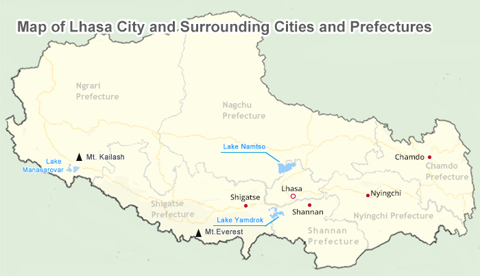 (Simple click to enlarge the map)Tibet Lhasa City and Surrounding Cities and Prefectures on Map
Situated in the middle of the Qinghai-Tibet Plateau, Lhasa Forbidden City is surrounded by Nyingchi City on the east, Shannan City on the south, Shigatse City on the west, Nagchu City on the north. To the far west and east of Lhasa are Ngari Prefecture and Chamdu City. Each city and prefecture has its own unique charms. The amazing highlights are listed as follows:
Nyingchi City: Peach Blossom Festival, Mount Namjagbarwa, Lulang Forest, Draksum-tso, Niyang River, Midui Glacier
Shannan City: Yumbulagang, Samye Monastery, Chim-puk Hermitage, Riduo Hot Spring, Yarlung Tsangpo Valley
Shigatse City: Mount Everest, Rongbuk Monastery, Tashilhunpo Monastery, Sakya Monastery, Pelkor Chode Monastery
Nagchu City: Nagchu Horse Racing Festival, Relics of Xiangxiong Kingdom, Changtang Plateau, Tangra Yum Tso
Ngari Prefecture: Mount Kailash, Lake Manasarovar, Guge Kingdom, Zanda Earth Forest, Tholing Monastery, Rutog Rock Paintings
Chamdu City: Rawok Lake, Riwoqe Monastery, Galden Jampaling Monastery, Wara Monastery, Kamaduo Stupas
Map of Tibet Lhasa and Surrounding Provinces in China
Lhasa City, the capital of China's Tibet Autonomous Region, is an international tourist city with spectacular alpine scenery and strong ethnic characteristics. Not only is Lhasa the political, economic, cultural and religious center of Tibet, but also it’s a holy land for Tibetan Buddhism.
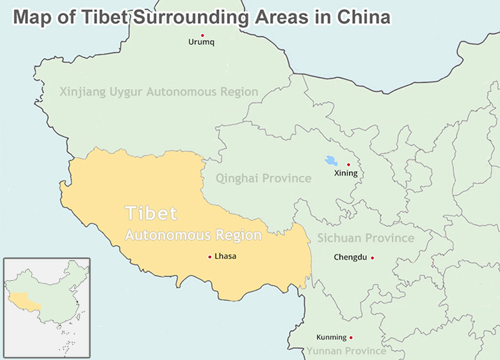 (Simple click to enlarge the map)Tibet Lhasa and Surrounding Provinces in China on Map
Lying in the southwestern part of the People's Republic of China, Tibet is neighboring three great provinces and one autonomous region in mainland China, namely Xinjiang Uygur Autonomous Region to the northwest, Qinghai Province to the northeast, Sichuan Province to the east, Yunnan Province to the southeast. Here I’d like to give you a brief introduction of top highlights in these provinces:
Xinjiang Uygur Autonomous Region: Turpan Scenic Spot (Grape Valley and Flaming Mountain), Koktokay Scenic Spot, Tianshan Grand Canyon, Kucha Palace, Narati Scenic Spot
Qinghai Province: Qinghai Lake, Birds Island, Chaka Salt Lake, Xining Dongguan Mosque, Ta'er Monastery, Menyuan Rape Flower Scenic Spot
Sichuan Province: Giant Panda Breeding Research Base, Jiuzhaigou and Huanglong Nature Reserve, Mount Emei, Leshan Giant Buddha, etc.
Yunnan Province: Stone Forest, Dian Lake, Dali Cang Mountain and Erhai Lake, Old Town of Lijiang, Shangrila, Meli Snow Mountain
Map of Tibet Lhasa and Surrounding Countries in Asia
Nestling on the north side of the Himalaya mountains, Tibet is so close to countries in Central and Southeast Asia, like India, Nepal, Bhutan and Myanmar, etc. Take Nepal for example. It’s so convenient for tourists to travel to Tibet Lhasa from Kathmandu Nepal either by flight or overland via Gyirong Port. And our Tibet travel gurus can also help you enjoy the epic Himalayan expedition with China, Tibet, Nepal, Bhutan altogether. Just take a quick glance at the most popular attractions in these neighboring countries near to Lhasa Tibet.
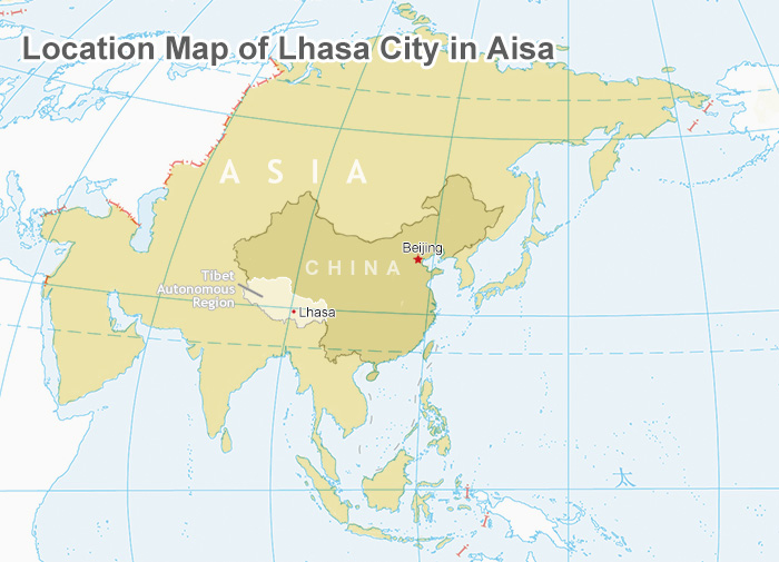 (Simple click to enlarge the map)Map of Lhasa Location in Asia
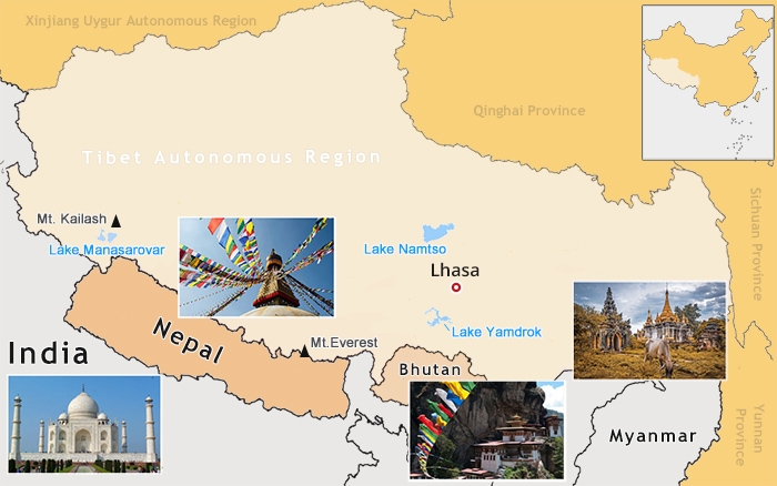 (Simple click to enlarge the map)Tibet Lhasa and Surrounding Countries in Asia on Map
Attractions in India: Taj Mahal, City Palace, Amber Fort, Meenakshi Amman Temple, Golden Temple, Sun Temple
Attractions in Nepal: Kathmandu’s Durbar Square, Swayambhunath Stupa, Bodhnath Stupa, Everest Base Camp trek in Nepal
Attractions in Bhutan: Tiger's Nest Monastery (Taktshang Goemba), Punakha Dzong, Paro Dzong, Kyichu Lhakhang
Attractions in Myanmar: Shwedagon Paya, Mandalay Hill, Bagaya Kyaung, Shwe In Bin Kyaung, Shittaung Paya
Map of Lhasa Location in the World
Sitting on the world’s highest plateau, Lhasa in Eurasian Plate warmly welcome international tourists with breathtaking natural scenery, mysterious Tibetan Buddhism, magnificent architecture and buildings, exotic custom and fantastic culture to experience. Just to name a few here, and Tibet has more to offer, why not work out your Lhasa tour with our professional expert?
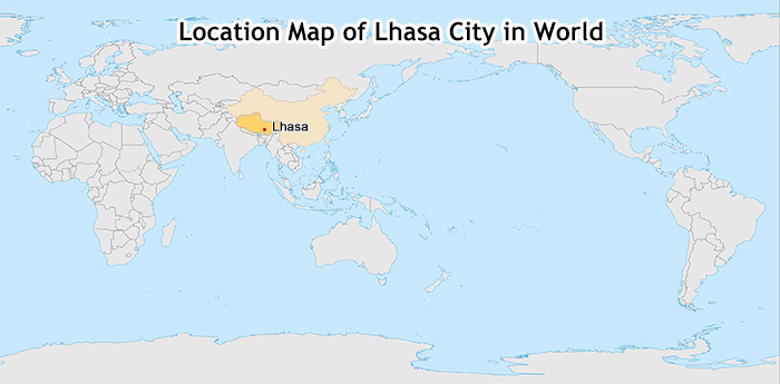 (Simple click to enlarge the map)Map of Lhasa Location in World
International and Domestic Flights to Lhasa Map
Definitely, taking flights to Tibet must be the most convenient way to get to Lhasa. When it comes to starting point, tourists have a wide range of choice to choose from, like the Capital City of China - Beijing, the bustling metropolis - Shanghai, the dynamic international harbor - Hong Kong, etc. By the way, the flight from Kathmandu to Lhasa is the only one international flight to Tibet available for tourists. If lucky enough, you can enjoy the superb vista of Mount Everest on the left seat.
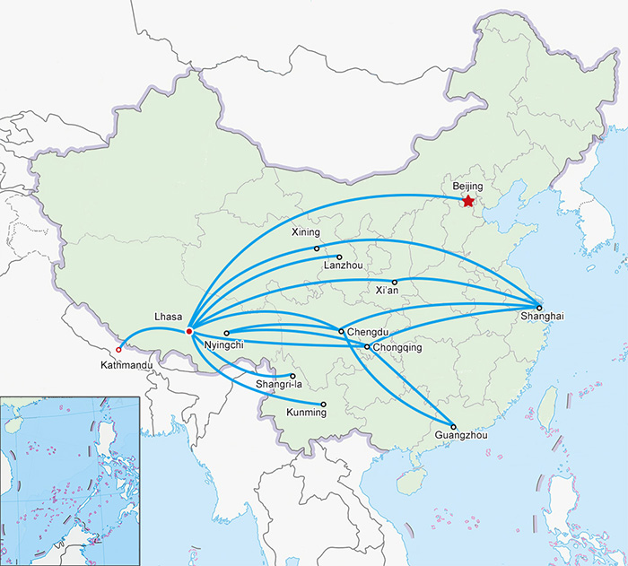 (Simple click to enlarge the map)Tibet Lhasa Flight Map
China Tibet Train to Lhasa Map
China has a comprehensive railway network, covering most part of the country. Upon arrival at the mainland China, you can easily get on the Tibet train to Lhasa from eight major gateway city, namely, Beijing, Shanghai, Guangzhou, Chengdu, Xining, Xian, Chongqing, Lanzhou. Although it’s slower than Lhasa flight, you can enjoy the magnificent alpine landscape along the world wonder - Qinghai-Tibet Railway and gradually get acclimatized to the high altitude in the sky train ride.
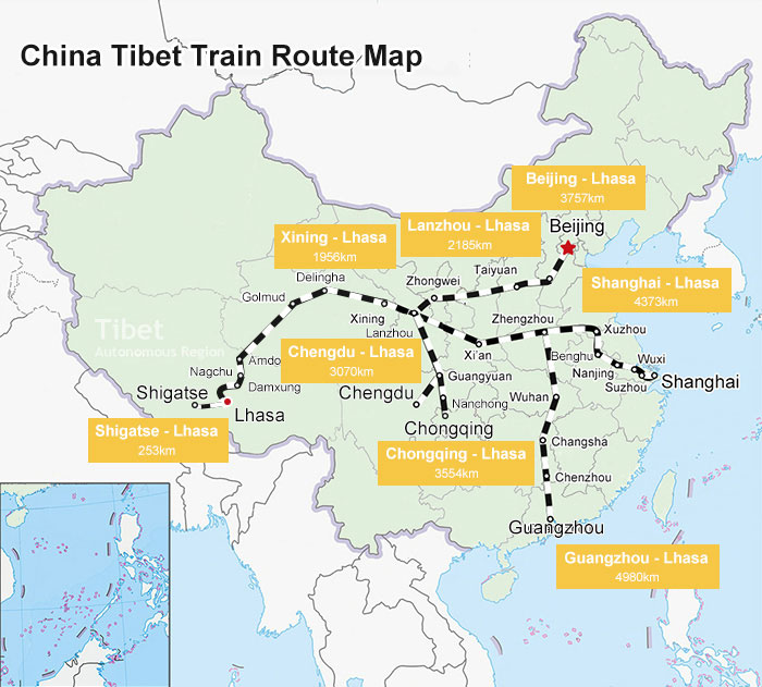 (Simple click to enlarge the map)Tibet Lhasa Train Route Map
Tibet Lhasa Overland Map
Current, five national highways have connected Tibet Lhasa with mainland China and Kathmandu Nepal, namely, Sichuan-Tibet Highway, Qinghai-Tibet Highway, Xinjiang Tibet Highway, Sino-Nepal Highway, Yunnan-Tibet Highway. As for the adventurers, travelling overland from mainland China to Lhasa Tibet must be the once-in-a-lifetime opportunity to explore the diverse landscapes of vast China and experience the brand-new customs and cultures.
.jpg) (Simple click to enlarge the map)Tibet Lhasa Overland Map with Distance
(Simple click to enlarge the map)Tibet Lhasa Overland Map with Distance
Hope all the maps above can clear out your concerns on Lhasa location. By the way, we also have elaborated out the Lhasa City Map and Lhasa Old Town Map to facilitate your deeper exploration to Lhasa city and towns. Please feel free to contact us and our Tibet travel guru are always here to help you out.

The Lhasa-born prodigy used to study business overseas, and got his Bachelor of Business in Nepal and India before moving back to his homeland. With pure passion for life and unlimited love for Tibet, Kunga started his guide career as early as 1997.
Responsible, considerate, and humorous, he devoted his entire life to guiding and serving international tourists traveling in Tibet. As a legendary Tibetan travel guru with 20-year pro guide experience. Currently, he is working in Tibet Vista as the Tour Operating Director. Whenever our clients run into trouble, he is your first call and will offer prompt support.

.jpg)


0 Comment ON "Where is Lhasa: how can I find the holy Lhasa City on map and get there?"