
Map of Tibet and Bhutan
Lying close together in the Himalayas, Tibet and Bhutan share a border of around 470 kilometers, along Bhutan’s northern border with China. With Tibet to the north, the rest of Bhutan is surrounded by the Indian states of Sikkim, Arunachal Pradesh, Assam, and West Bengal. Geographically, Bhutan lies on the southern edge of the Western Himalayas, and directly north of the Bay of Bengal. Tibet, on the other hand, is not a country in its own right, but a region of the People’s Republic of China, known as the Tibet Autonomous Region, and is bordered by Bhutan and India to the south, Nepal to the west, the Chinese area of the Xinjiang Uyghur Autonomous Prefecture and Qinghai Province to the north, and the provinces of Gansu, Yunnan, and Sichuan to the west and southwest. Geopolitically, Bhutan and Tibet are both located in South Asia. Follow our expertly-made map of Tibet and Bhutan to better plan your Tibet and Bhutan tour.
Key Information of Tibet and Bhutan on the Map
Capital of Tibet and Bhutan
The capital city of Tibet is a regional capital, Lhasa, and is located in the southwestern central area of the region. The highest capital city in the world, Lhasa lies at an altitude of around 3,656 meters above sea level, though its highest point, the famous Potala Palace, is around 300 meters higher. Known as the City of Sunshine, due to the huge number of sunny days the city experiences throughout the year, this ancient city was founded in the 7th century by the 33rd king of Tibet, Songtsen Gampo, as the new capital of the former Tibetan Empire. Now a prefecture-level city, with the administrative center in the city of Lhasa itself, it is one of seven prefectures in the Tibet Autonomous Region. - See more tours in Lhasa, Tibet
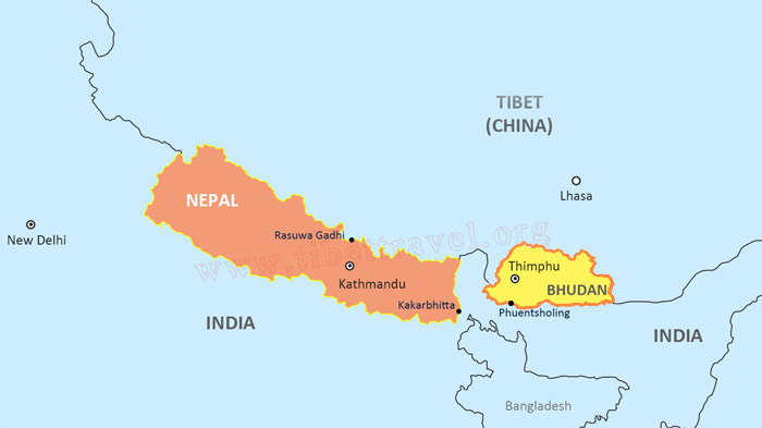 Location of Lhasa and Thimphu on Map
Thimphu, the modern capital of Bhutan, was only named as the new capital in 1955, and was inaugurated as the official national capital in 1961 by the 3rd King of Bhutan, Druk Gyalpo Jigme Dorje Wangchuck. Formerly, the Bhutanese capital was at Punakha, which had been the ancient capital of the kingdom since the founding of the country. Thimphu is the largest and most populous city in Bhutan, and lies in the western central region of the kingdom. Lying on the western bank of the Wang Chhu, a river which flows through the Thimphu Valley, the city extends in a north-south direction, and lies at an average altitude of around 2,448 meters above sea level.
Geographical feature of Tibet and Bhutan
Tibet lies on the world’s highest plateau, and its altitude ranges from as low as 2,400 meters to as high as 8,848 meters, which is the highest point on the plateau at the summit of Mount Everest. However, the recognized average elevation of the plateau, and of Tibet, is around 4,800 meters above sea level. - See Your Definitive Maps of Tibet Plateau and Tibet Tourism
Bhutan is a little different, with high mountains to the north and lowlands in the south, and the average elevation of the kingdom being around 3,280 meters above sea level. In the north, the mountains reach altitudes of over 7,000 meters, while in the south, some of the lowlands along the border are only around 300-400 meters, level with the plains of northern Assam and West Bengal. Bhutan also has a much bigger percentage of forested land than Tibet, where the majority of the plateau’s forests are around some of the deeper valleys and in the Nyingchi area. Around 65 percent of Bhutan is covered in forests at any time, as part of their ecological policies. - See more detailed information about Bhutan Maps
Different weather patterns in Tibet and Bhutan
Bhutan has a sub-tropical temperate climate, with a high-altitude alpine climate in the far north along the line of the Himalayas. Most of the country comes under the subtropical region, with a harsher monsoon in the summer and milder winters, while in the north, the winters are extremely cold and there is a lot less rain in the monsoon season. - See Best Time to Visit Bhutan
Tibet has a typical sub-tropical plateau climate, with colder winters and lower rainfall in the monsoon season, due to the shadow effect of the Himalayas reducing the impact of the southwest Indian monsoon on the plateau environment. Summer rains across most of the plateau are lighter, with the rainfall mostly occurring in the late evenings and overnight. Nyingchi is the exception, as it has a higher level of monsoon rainfall, with much milder winters. - See the ultimate guide about when to tour Tibet
How to travel between Tibet and Bhutan on the Map
Travel from Bhutan to Tibet and vice versa can be done overland or by flights. Kathmandu links the two destinations as the hub for flights into Bhutan and Tibet, with daily flights to both Lhasa and Paro.
Flights between Kathmandu and Lhasa can cost as little as 300 dollars in the low season, up to around 500 dollars in the peak season. Flights run daily to Lhasa Gonggar International Airport, and take around 90 minutes. The flights to Bhutan’s Paro International Airport take around 1 hour 15 minutes, and can cost from as little as US$196 per person in the low season. Flights are run by Bhutan’s two airlines, DrukAir and Bhutan Airlines, and run daily to the kingdom.
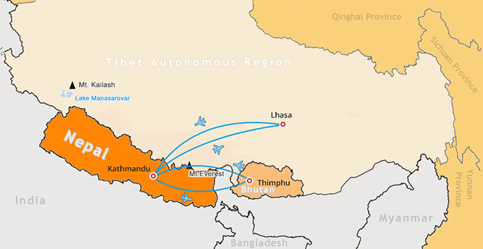 Currently, taking flight is the only way to travel between Tibet and Bhutan.
Travel overland from Nepal to Tibet is one of the best ways to get to Lhasa, and is a trip of around 7-8 days. The route takes you from Kathmandu to the border with China at Rasuwa Gandhi, and once across the border, you will be met by your guide and driver and taken to Gyirong Town for the night. From there, you will travel along the Friendship Highway, passing through Everest Base Camp, Shigatse, and Gyantse, before reaching the Tibetan capital of Lhasa.
If you are planning a trip to Bhutan overland, you will need to pass through India, as it lies between Bhutan and Nepal. The route takes you by bus from Kathmandu to Kakarbhitta, on the border with India, where you cross to the Indian border town of Panitanki. From there, a local bus can take you to Siliguri, where you can get a direct train to Hasimara, the closest railway station to Bhutan. Buses run from Hasimara to Jaigaon, on the India-Bhutan border, where you will cross to the Bhutanese border town of Phuentsholing. From there, your guide will collect you and take you to Thimphu, the Bhutanese capital. - See the ultimate guide about how to get to Bhutan from different countries
Top Travel Routes in Tibet and Bhutan on the Map
Best Travel Routes in Tibet
There are four main routes for tourists to Tibet, which are the most popular tours in the region on the high-altitude plateau. The first takes you out of Lhasa, after exploring the delights of the city, including the Potala Palace, Jokhang temple and the monasteries of Sera and Drepung. You will then travel along the Friendship Highway, past the stunning Lake Yamdrok, to Gyantse, where you will get chance to visit the beauty of the Gyantse Kumbum. Then it is on to Shigatse, to visit the Tashilhunpo Monastery, before heading off to explore the stunning Mount Everest, at the Everest Base Camp (EBC). After visiting EBC, your tour then takes you back to Lhasa, following the Friendship Highway.
The route to Mount Kailash, the most sacred mountain in the world, also starts with the highlights of Lhasa, and heads out to Gyantse and Shigatse, before taking in the Everest Base Camp. From there, you head northwest, passing through Saga and other small towns to the village of Darchen, which lies at the southern edge of Mount Kailash, and to the north of Lake Manasarovar. You can then take the trek around the Kailash Kora, one of the hardest treks in Tibet, which takes three days of trekking around 8 hours per day.
Another great tour is the one that takes you to Lake Namtso, to the north of Lhasa. Once you have acclimatized in Lhasa, and seen the stunning sights of the city, you will travel north along the Qinghai Tibet Highway, and then across the high pass over the Nyenchen Tanglha Mountains to drop down to the lake. The trip to Lake Namtso takes around 6-8 hours, and you can stay overnight at the lakeside before traveling back to Lhasa the following day. On the return journey, you will be able to stop at the amazing Yangpachen Hot Springs to relax for a while and enjoy the refreshing waters. Check the datailed itineraries of Lhasa Nyingchi tour
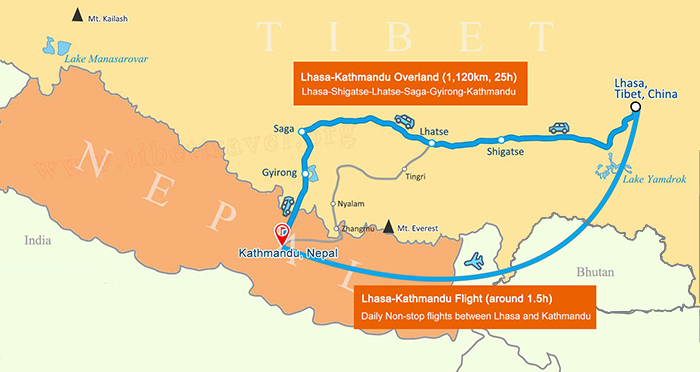 The most classic Lhasa to Kathmandu overland route.
For those traveling on the Nepal after their Tibet tour, the best option is the Lhasa to Kathmandu overland tour, which takes you through Gyantse and Shigatse to Everest Base Camp. Then you will travel to Gyirong town for the night, before being taken to the Sino-Nepal border checkpoint at Gyirong Port. Once across the border, you will be able to get your visa on arrival, before getting a public bus or shuttle van to the Nepali capital of Kathmandu. The trip to the capital takes around 6 hours, and the bus stops along the way for a light lunch.
Best Travel Routes In Bhutan
Bhutan has some of the most stunning scenery in the world, and one of the most popular travel routes is from Paro to the capital at Thimphu, and then on to Punakha, one of the main trekking regions in Bhutan. The normal tour starts in Paro, and gives you a great chance to visit the Tachog Lhakhang, as well as heading to Chunzom, the confluence of Pachu and Wangchu Rivers. You will then drive on to Punakha, crossing the Dochula Pass and stopping at the 108 Chortens site along the way, a monument to the former King of Bhutan. - Check the best Bhutan tours
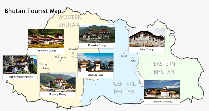 Map of Major tourist attractions in Bhutan
In Punakha, one of the most beautiful regions in Bhutan, you will be able to visit the Chhimi Lhakhang, the Punakha Dzong, and explore the city, before heading back to the west to visit Thimphu, the Bhutanese capital. In Thimphu, you can visit the Traditional Arts and Crafts Painting School, the National Textile Museum, the Bhutan Postal Museum, the Takin Preserve, the National Memorial Chorten, and many other amazing sights.
The other main route through Bhutan on an organized tour takes you off to the east of the country, heading from Punakha to visit the areas of Wangdue Phodrang, for the Phobjika Valley, and the Bumthang District. Wangdue Phodrang is to the southeast of Punakha, and is the location of the stunning Phobjika Valley, a part of the Jigme Singye Wangchuck National Park. One of the most important bird and animal sanctuaries in Bhutan, the valley is home to the black-necked cranes for their winter feeding grounds, as well as being a haven for wild yaks, and an important grazing area of the local yak herders and shepherds.
Bumthang is one of the eastern districts of Bhutan and is a great area for trekking in the kingdom. There are also some great places to visit in the area, such as the Tamshing Lhakhang, also known as the temple of Good message, the Tibetan-built Jambey Lhakhamg, commissioned by the Tibetan king, Songtsen Gampo in the 7th century, and the Jakar Dzong, one of the most thrilling examples of Bhutanese Buddhist architecture in the kingdom.

The Lhasa-born prodigy used to study business overseas, and got his Bachelor of Business in Nepal and India before moving back to his homeland. With pure passion for life and unlimited love for Tibet, Kunga started his guide career as early as 1997.
Responsible, considerate, and humorous, he devoted his entire life to guiding and serving international tourists traveling in Tibet. As a legendary Tibetan travel guru with 20-year pro guide experience. Currently, he is working in Tibet Vista as the Tour Operating Director. Whenever our clients run into trouble, he is your first call and will offer prompt support.

.jpg)


0 Comment ON "Map of Tibet and Bhutan"