
Bhutan Border Map/Bhutan Map with Surrounding Countries
Travelers all over the world always find perplexed about why Bhutan, this small and Buddhism predominated nation, has once taken Gross National Happiness more important than Gross National Product. Is it some kind of belief? Is it because that the country locates in a superior terrain with some peaceful and stable surrounded developing countries? Or is it just a kind of living philosophy?
To find these answers, why not take an amazing trip to this mysterious land and make a chance to experience its bordering countries with your friends or families. To help you get a worry-free tour, we have collected maps and information about Bhutan border countries and areas.
What are you waiting for? Let’s explore this socio-economic self-sufficient kingdom through their enviable living environment and daily life by getting familiar with its border countries and Bhutan Himalayas.
What are the bordering countries and areas of Bhutan?
The Kingdom of Bhutan is a sovereign nation located towards the eastern extreme of the Himalayas mountain range. It is evenly sandwiched between the sovereign territories of two nations: China and India.
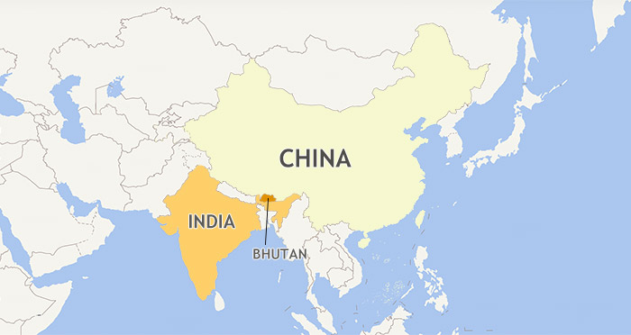 Bhutan with both of its bordering countries China and India on map.
Bhutan borders Tibet Autonomous Region of China on the north and northwest with the borderline of approximately 477 km and the Arunachal Pradesh, Assam, West Bengal, as well as Sikkim of India on the south with the borderline of approximately 659 km.
Bhutan's total borders amount to 1,139 kilometers. The Republic of Nepal to the west, the People's Republic of Bangladesh to the south, and the Union of Myanmar to the southeast are other close neighbors; the former two are separated by only very small stretches of Indian Territory.
Here, we provide detailed information about Bhutan’s bordering countries and areas to help you better understand this country from a geographical perspective.
Bhutan China Border Map and Bhutan Himalaya Map
Bhutan Border Country - China
Location: East Asia
Capital: Beijing
Population: 1.38 billion
Official language: Mandarin
Ethnicity: Officially 56 ethnic groups with Han Chinese top the most
Festivals: Chinese New Year, Lantern Festival, Dragon Boat Festival, Qingming Festival (Tomb-sweeping Day), Double Seventh Festival, Mid-autumn Festival, Double Ninth Festival, Winter Solstice, Laba Festival.
Religions: Officially espouses state atheism. Chinese civilization has been influenced by various religious movements. The “Three Teachings”, including Confucianism, Taoism, and Chinese Buddhism, play a significant role in shaping Chinese Culture.
Economy: The largest economy in the world, world’s second-largest economy in terms of Nominal GDP, the largest in the world in terms of Purchasing Power Parity GDP since 2016.
Bhutan China border is a 470 km curving line stretching in the north and northwest of Bhutan. In the northeastern part, the two countries are bordered by Himalaya Range with a great number of high altitude mountains.
Like China Tibet, there are so many places spotted in Bhutan to get a panoramic view of solemn Himalaya Mountains, some are along the trekking routes while others are on the high altitude passes or in the high elevation valleys in northwestern part of Bhutan. It is possible for you to enjoy a changing view of the Himalaya Range from these spectacular places. Here we have handpicked the most popular Tibet Bhutan Tour, Tibet Nepal Bhutan Tour, and China Tibet Nepal Bhutan Tour for you to choose from.
India Nepal and Bhutan Map
Another country that worth mentioning is Nepal, for both of the two countries, is not only geographically and culturally related, but enjoys a convenient tourist airline transportation.
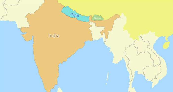 (Simple click to enlarge the map)
India Nepal and Bhutan Location on Map
Tourists over the world only have two ways to travel to Bhutan - take a flight to Bhutan from the airports of nearby countries or drive overland to Bhutan from India. The Tribhuvan International Airport in Kathmandu, the capital city of Nepal, is one of a few airports that manage a direct international flight to Paro in Bhutan. Longing to delve into the Himalayan countries altogether? No worries! Here we have designed out the most classic Nepal Bhutan Tour and India Nepal Tibet Bhutan Tour for you.
India Bhutan Doklam Map
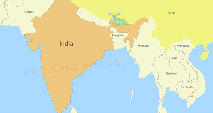 (Simple click to enlarge the map)
Doklam Plateau between Tibet and Bhutan in near India.
Bhutan Border Country - India
Location: South Asia
Capital: New Delhi
Population: 1.3 billion
Official language: Hindi
Ethnicity: Bhutias, Lepchas, Tibetans, Biharis, Bengalis, Marwaris
Festivals: Diwali
Religions: Hinduism (79.80% of the population), Islam (14.23%), Christianity (2.30%), Sikhism (1.72%), Buddhism (0.70%), Jainism (0.36%) and others (0.9%). India has the world's largest Hindu, Sikh, Jain, Zoroastrian, and Bahá'í populations, and has the third-largest Muslim population - the largest for a non-Muslim majority country.
Economy: According to the International Monetary Fund (IMF), the Indian economy was nominally worth USD 2.611 trillion two years ago; it is the sixth-largest economy by market exchange rates, and is, at USD 9.459 trillion, the third-largest by purchasing power parity.
Transport: Air and roads
Air: 346 civilian airfields in India - 253 with paved runways and 93 with unpaved runways, only 132 were classified as "airports". Of these, Indira Gandhi International Airport in Delhi is the busiest in the country.
Rail: India railway network traverses through the length and breadth of the country, covering more than 7,000 stations over a total route length of more than 65,000 km and track length of about 115,000 km. About 22,224 km or 34% of the route-kilometre was electrified as on 31 March 2012.
IR (Indian Railways) provides an important mode of transport in India, transporting over 18 million passengers and more than 2 million tons of freight daily across one of the largest and busiest rail networks in the world.
High-speed rail, International links, suburban rail, metro, monorail, light rail, and train are the main railways in current India.
Insider tips:
If you want to get to Bhutan from India by train, then you need to take a train journey to Hasimara that located in eastern India and only 17 km away from Phuentsholing, the second largest city in the southwest of Bhutan.
Roads: India has been building roads since ancient times as is evident from the Harappa civilization. The total road length in India is 5,603,293 km, making the Indian road network the second largest road network in the world after the United States.
India Sikkim Bhutan Map/Bhutan and Sikkim Map
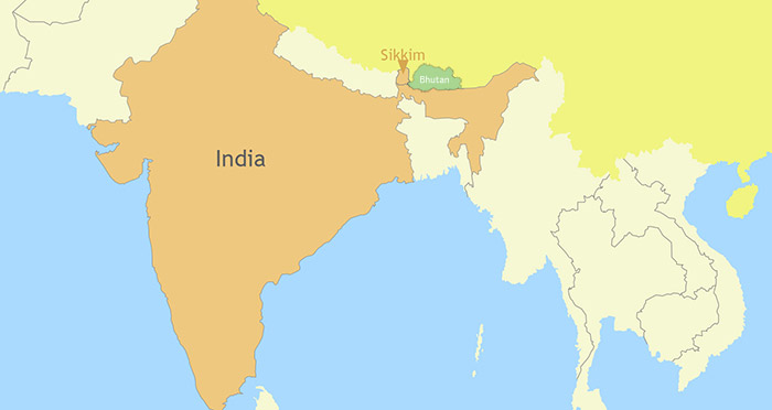 (Simple click to enlarge the map)
Bhutan borders India Sikkim in Its West
Bhutan Border - Indian State Sikkim
Location: Northeast of India, between Nepal and Bhutan
Official language: Nepali, Sikkimese, Lepcha, Tamang, Limbu, Newari, Rai, Gurung, Magar, Sunwar and English (English is widely taught in school and used in government document)
Population: About 600,000
Ethnicity: Bhutias, Lepchas, Tibetans, Biharis, Bengalis, Marwaris
Festivals: Diwali, Dussehra, Maghe Sankranti, Bhimsen Puja, Losar, Loosong, Saga Dawa, Lhabab Duechen, Drupka Teshi and Bhumchu
Most of Sikkim's Nepalese celebrate all major Hindu festivals, including Diwali and Dussera. Traditional local festivals, such as Maghe Sankranti and Bhimsen Puja, are popular. Losar, Loosong, Saga Dawa, Lhabab Duechen, Drupka Teshi and Bhumchu are among the Buddhist festivals celebrated in Sikkim. During the Losar (Here to see the Losar in Tibet), most offices and educational institutions are closed for a week.
Predominate religions: Hinduism and Vajrayana Buddhism
Transport: Air and roads
Air: Pakyong Airport, the first airport of the India state built by Airports Authority of India at the altitude of 1,400 m (4,700 ft.) and opened in Oct. 2018
Roads: More than 30 highways with the total traffic millage of about 1,500 km, among which more than 500 km is the asphalt paved roads
Sikkim is a multiethnic and multilingual state in the northeast of India and it borders Tibet Autonomous Region of China in the north, Bhutan in the east, Nepal in the west and India state of West Bengal in the south. With the second smallest but the least populated state among the Indian states, Sikkim is notable for its biodiversity and about 35% of the state is covered by the Khangchendzonga National Park.

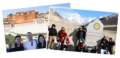
I am a tour guide in Tibet an was Born in Kham Tibet, I am the father of 2 little girls, bachelor's degree. I have more than 7-years experience of being a tour guide in Tibet. I am a warm, friendly, knowledgeable and attractive guy.

.jpg)


0 Comment ON "Bhutan Border Map/Bhutan Map with Surrounding Countries"